You are here: Home > Network List > TA - USArray Transportable Network (new EarthScope stations) Stations List
> Station A14A Double T Ranch, Babb, MT, USA > Earthquake Result Viewer
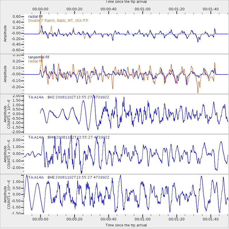
A14A Double T Ranch, Babb, MT, USA - Earthquake Result Viewer
*The percent match for this event was below the threshold and hence no stack was calculated.
| Earthquake location: |
Andreanof Islands, Aleutian Is. |
| Earthquake latitude/longitude: |
51.6/-174.4 |
| Earthquake time(UTC): |
2008/11/02 (307) 13:48:42 GMT |
| Earthquake Depth: |
36 km |
| Earthquake Magnitude: |
5.7 MB, 5.8 MS, 6.1 MW, 6.1 MW |
| Earthquake Catalog/Contributor: |
WHDF/NEIC |
|
| Network: |
TA USArray Transportable Network (new EarthScope stations) |
| Station: |
A14A Double T Ranch, Babb, MT, USA |
| Lat/Lon: |
48.97 N/113.42 W |
| Elevation: |
1420 m |
|
| Distance: |
38.1 deg |
| Az: |
69.124 deg |
| Baz: |
297.706 deg |
| Ray Param: |
$rayparam |
*The percent match for this event was below the threshold and hence was not used in the summary stack. |
|
| Radial Match: |
62.89674 % |
| Radial Bump: |
378 |
| Transverse Match: |
57.80389 % |
| Transverse Bump: |
392 |
| SOD ConfigId: |
2658 |
| Insert Time: |
2010-03-07 00:29:02.683 +0000 |
| GWidth: |
2.5 |
| Max Bumps: |
400 |
| Tol: |
0.001 |
|
Signal To Noise
| Channel | StoN | STA | LTA |
| TA:A14A: :BHN:20081102T13:55:27.473992Z | 2.8962352 | 1.1049475E-6 | 3.8151165E-7 |
| TA:A14A: :BHE:20081102T13:55:27.473992Z | 0.96728027 | 8.169739E-7 | 8.446093E-7 |
| TA:A14A: :BHZ:20081102T13:55:27.473992Z | 2.5536218 | 1.3096427E-6 | 5.1285696E-7 |
| Arrivals |
| Ps | |
| PpPs | |
| PsPs/PpSs | |


