You are here: Home > Network List > TA - USArray Transportable Network (new EarthScope stations) Stations List
> Station R33M Jennings River, BC, CAN > Earthquake Result Viewer
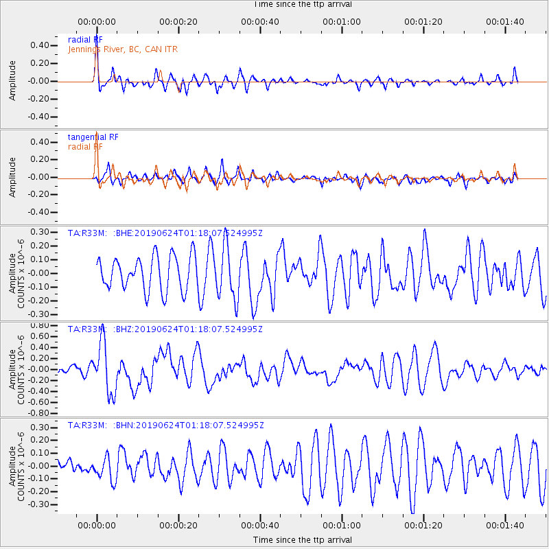
R33M Jennings River, BC, CAN - Earthquake Result Viewer
*The percent match for this event was below the threshold and hence no stack was calculated.
| Earthquake location: |
Irian Jaya, Indonesia |
| Earthquake latitude/longitude: |
-2.9/138.5 |
| Earthquake time(UTC): |
2019/06/24 (175) 01:05:28 GMT |
| Earthquake Depth: |
22 km |
| Earthquake Magnitude: |
6.1 Mww |
| Earthquake Catalog/Contributor: |
NEIC PDE/us |
|
| Network: |
TA USArray Transportable Network (new EarthScope stations) |
| Station: |
R33M Jennings River, BC, CAN |
| Lat/Lon: |
59.39 N/130.97 W |
| Elevation: |
1437 m |
|
| Distance: |
92.7 deg |
| Az: |
30.811 deg |
| Baz: |
269.009 deg |
| Ray Param: |
$rayparam |
*The percent match for this event was below the threshold and hence was not used in the summary stack. |
|
| Radial Match: |
64.19727 % |
| Radial Bump: |
341 |
| Transverse Match: |
54.768757 % |
| Transverse Bump: |
382 |
| SOD ConfigId: |
18369291 |
| Insert Time: |
2019-07-08 01:10:41.307 +0000 |
| GWidth: |
2.5 |
| Max Bumps: |
400 |
| Tol: |
0.001 |
|
Signal To Noise
| Channel | StoN | STA | LTA |
| TA:R33M: :BHZ:20190624T01:18:07.524995Z | 6.7355604 | 4.726776E-7 | 7.0176434E-8 |
| TA:R33M: :BHN:20190624T01:18:07.524995Z | 0.8905987 | 9.3166676E-8 | 1.0461129E-7 |
| TA:R33M: :BHE:20190624T01:18:07.524995Z | 1.5879664 | 1.9452784E-7 | 1.2250122E-7 |
| Arrivals |
| Ps | |
| PpPs | |
| PsPs/PpSs | |


