You are here: Home > Network List > TA - USArray Transportable Network (new EarthScope stations) Stations List
> Station C15A Salmond Ranch, Choteau, MT, USA > Earthquake Result Viewer
C15A Salmond Ranch, Choteau, MT, USA - Earthquake Result Viewer
| Earthquake location: |
Fiji Islands Region |
| Earthquake latitude/longitude: |
-17.3/-177.3 |
| Earthquake time(UTC): |
2008/07/19 (201) 22:39:52 GMT |
| Earthquake Depth: |
391 km |
| Earthquake Magnitude: |
5.9 MB, 6.4 MW, 6.4 MW |
| Earthquake Catalog/Contributor: |
WHDF/NEIC |
|
| Network: |
TA USArray Transportable Network (new EarthScope stations) |
| Station: |
C15A Salmond Ranch, Choteau, MT, USA |
| Lat/Lon: |
47.78 N/112.61 W |
| Elevation: |
1522 m |
|
| Distance: |
86.8 deg |
| Az: |
37.649 deg |
| Baz: |
239.876 deg |
| Ray Param: |
0.042805556 |
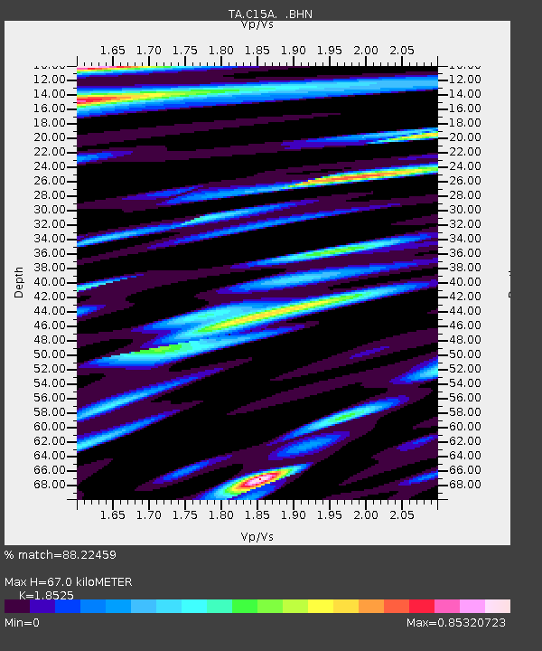
| Estimated Moho Depth: |
67.0 km |
| Estimated Crust Vp/Vs: |
1.85 |
| Assumed Crust Vp: |
6.353 km/s |
| Estimated Crust Vs: |
3.429 km/s |
| Estimated Crust Poisson's Ratio: |
0.29 |
|
| Radial Match: |
88.22459 % |
| Radial Bump: |
400 |
| Transverse Match: |
76.003105 % |
| Transverse Bump: |
400 |
| SOD ConfigId: |
2504 |
| Insert Time: |
2010-03-07 00:29:36.564 +0000 |
| GWidth: |
2.5 |
| Max Bumps: |
400 |
| Tol: |
0.001 |
|
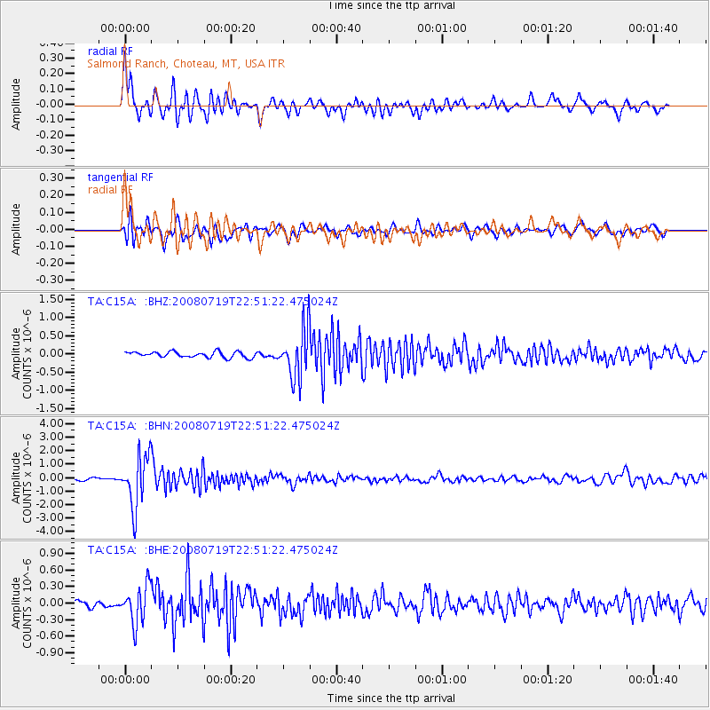
Signal To Noise
| Channel | StoN | STA | LTA |
| TA:C15A: :BHN:20080719T22:51:22.475024Z | 23.861065 | 1.9228657E-6 | 8.058592E-8 |
| TA:C15A: :BHE:20080719T22:51:22.475024Z | 6.060355 | 3.4490353E-7 | 5.691144E-8 |
| TA:C15A: :BHZ:20080719T22:51:22.475024Z | 8.630884 | 6.81913E-7 | 7.900847E-8 |
| Arrivals |
| Ps | 9.2 SECOND |
| PpPs | 29 SECOND |
| PsPs/PpSs | 39 SECOND |


