You are here: Home > Network List > TA - USArray Transportable Network (new EarthScope stations) Stations List
> Station C15A Salmond Ranch, Choteau, MT, USA > Earthquake Result Viewer
C15A Salmond Ranch, Choteau, MT, USA - Earthquake Result Viewer
| Earthquake location: |
Off East Coast Of Honshu, Japan |
| Earthquake latitude/longitude: |
37.2/142.1 |
| Earthquake time(UTC): |
2008/07/21 (203) 11:30:29 GMT |
| Earthquake Depth: |
22 km |
| Earthquake Magnitude: |
5.7 MB, 5.6 MS, 6.0 MW, 5.9 MW |
| Earthquake Catalog/Contributor: |
WHDF/NEIC |
|
| Network: |
TA USArray Transportable Network (new EarthScope stations) |
| Station: |
C15A Salmond Ranch, Choteau, MT, USA |
| Lat/Lon: |
47.78 N/112.61 W |
| Elevation: |
1522 m |
|
| Distance: |
72.4 deg |
| Az: |
43.023 deg |
| Baz: |
306.116 deg |
| Ray Param: |
0.05363789 |
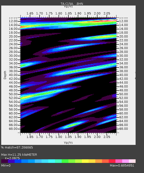
| Estimated Moho Depth: |
11.25 km |
| Estimated Crust Vp/Vs: |
2.10 |
| Assumed Crust Vp: |
6.353 km/s |
| Estimated Crust Vs: |
3.029 km/s |
| Estimated Crust Poisson's Ratio: |
0.35 |
|
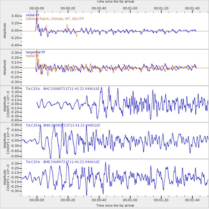
| Radial Match: |
87.286865 % |
| Radial Bump: |
400 |
| Transverse Match: |
70.770004 % |
| Transverse Bump: |
400 |
| SOD ConfigId: |
2504 |
| Insert Time: |
2010-03-07 00:29:39.587 +0000 |
| GWidth: |
2.5 |
| Max Bumps: |
400 |
| Tol: |
0.001 |
|
Signal To Noise
| Channel | StoN | STA | LTA |
| TA:C15A: :BHN:20080721T11:41:22.649019Z | 6.076804 | 3.9824445E-7 | 6.5535176E-8 |
| TA:C15A: :BHE:20080721T11:41:22.649019Z | 1.2117215 | 7.66993E-8 | 6.329779E-8 |
| TA:C15A: :BHZ:20080721T11:41:22.649019Z | 1.639796 | 9.0848886E-8 | 5.5402555E-8 |
| Arrivals |
| Ps | 2.0 SECOND |
| PpPs | 5.3 SECOND |
| PsPs/PpSs | 7.3 SECOND |


