You are here: Home > Network List > TA - USArray Transportable Network (new EarthScope stations) Stations List
> Station C15A Salmond Ranch, Choteau, MT, USA > Earthquake Result Viewer
C15A Salmond Ranch, Choteau, MT, USA - Earthquake Result Viewer
| Earthquake location: |
Virgin Islands |
| Earthquake latitude/longitude: |
19.2/-64.8 |
| Earthquake time(UTC): |
2008/10/11 (285) 10:40:14 GMT |
| Earthquake Depth: |
23 km |
| Earthquake Magnitude: |
6.1 MB, 5.9 MS, 6.1 MW, 6.0 MW |
| Earthquake Catalog/Contributor: |
WHDF/NEIC |
|
| Network: |
TA USArray Transportable Network (new EarthScope stations) |
| Station: |
C15A Salmond Ranch, Choteau, MT, USA |
| Lat/Lon: |
47.78 N/112.61 W |
| Elevation: |
1522 m |
|
| Distance: |
48.0 deg |
| Az: |
317.754 deg |
| Baz: |
109.577 deg |
| Ray Param: |
0.069614284 |
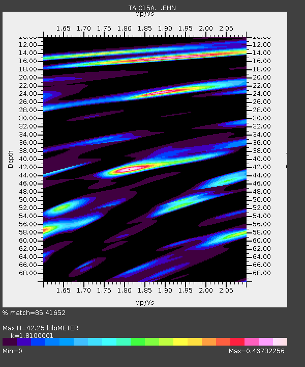
| Estimated Moho Depth: |
42.25 km |
| Estimated Crust Vp/Vs: |
1.81 |
| Assumed Crust Vp: |
6.353 km/s |
| Estimated Crust Vs: |
3.51 km/s |
| Estimated Crust Poisson's Ratio: |
0.28 |
|
| Radial Match: |
85.41652 % |
| Radial Bump: |
400 |
| Transverse Match: |
62.29858 % |
| Transverse Bump: |
400 |
| SOD ConfigId: |
2556 |
| Insert Time: |
2010-03-07 00:29:53.771 +0000 |
| GWidth: |
2.5 |
| Max Bumps: |
400 |
| Tol: |
0.001 |
|
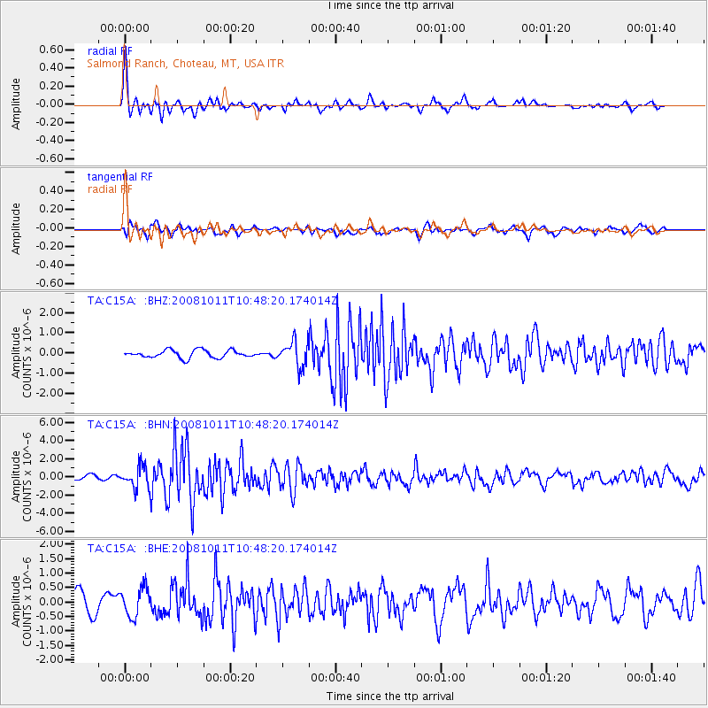
Signal To Noise
| Channel | StoN | STA | LTA |
| TA:C15A: :BHN:20081011T10:48:20.174014Z | 4.543927 | 1.185105E-6 | 2.6081074E-7 |
| TA:C15A: :BHE:20081011T10:48:20.174014Z | 1.628348 | 4.942808E-7 | 3.0354744E-7 |
| TA:C15A: :BHZ:20081011T10:48:20.174014Z | 3.305607 | 6.3511914E-7 | 1.921339E-7 |
| Arrivals |
| Ps | 5.7 SECOND |
| PpPs | 18 SECOND |
| PsPs/PpSs | 23 SECOND |


