You are here: Home > Network List > AK - Alaska Regional Network Stations List
> Station YAH Yahtse, AK, USA > Earthquake Result Viewer
YAH Yahtse, AK, USA - Earthquake Result Viewer
| Earthquake location: |
Banda Sea |
| Earthquake latitude/longitude: |
-6.4/129.2 |
| Earthquake time(UTC): |
2019/06/24 (175) 02:53:39 GMT |
| Earthquake Depth: |
212 km |
| Earthquake Magnitude: |
7.3 mww |
| Earthquake Catalog/Contributor: |
NEIC PDE/us |
|
| Network: |
AK Alaska Regional Network |
| Station: |
YAH Yahtse, AK, USA |
| Lat/Lon: |
60.36 N/141.75 W |
| Elevation: |
2125 m |
|
| Distance: |
95.1 deg |
| Az: |
29.932 deg |
| Baz: |
266.03 deg |
| Ray Param: |
0.04071166 |
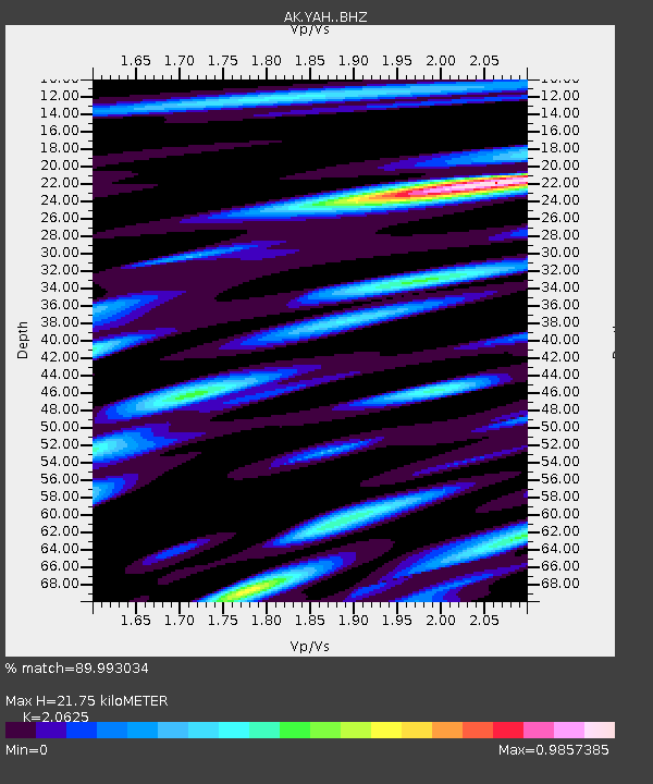
| Estimated Moho Depth: |
21.75 km |
| Estimated Crust Vp/Vs: |
2.06 |
| Assumed Crust Vp: |
6.566 km/s |
| Estimated Crust Vs: |
3.184 km/s |
| Estimated Crust Poisson's Ratio: |
0.35 |
|
| Radial Match: |
89.993034 % |
| Radial Bump: |
400 |
| Transverse Match: |
85.27396 % |
| Transverse Bump: |
400 |
| SOD ConfigId: |
18369291 |
| Insert Time: |
2019-07-08 02:55:00.438 +0000 |
| GWidth: |
2.5 |
| Max Bumps: |
400 |
| Tol: |
0.001 |
|

Signal To Noise
| Channel | StoN | STA | LTA |
| AK:YAH: :BHZ:20190624T03:06:06.98802Z | 34.769234 | 3.7998136E-6 | 1.0928667E-7 |
| AK:YAH: :BHN:20190624T03:06:06.98802Z | 7.2985864 | 1.0873696E-6 | 1.4898357E-7 |
| AK:YAH: :BHE:20190624T03:06:06.98802Z | 11.514558 | 1.4106804E-6 | 1.2251277E-7 |
| Arrivals |
| Ps | 3.6 SECOND |
| PpPs | 10.0 SECOND |
| PsPs/PpSs | 14 SECOND |


