You are here: Home > Network List > TA - USArray Transportable Network (new EarthScope stations) Stations List
> Station C15A Salmond Ranch, Choteau, MT, USA > Earthquake Result Viewer
C15A Salmond Ranch, Choteau, MT, USA - Earthquake Result Viewer
| Earthquake location: |
Santiago Del Estero Prov., Arg. |
| Earthquake latitude/longitude: |
-26.7/-63.2 |
| Earthquake time(UTC): |
2008/09/03 (247) 11:25:14 GMT |
| Earthquake Depth: |
570 km |
| Earthquake Magnitude: |
5.9 MB, 6.3 MW, 6.3 MW |
| Earthquake Catalog/Contributor: |
WHDF/NEIC |
|
| Network: |
TA USArray Transportable Network (new EarthScope stations) |
| Station: |
C15A Salmond Ranch, Choteau, MT, USA |
| Lat/Lon: |
47.78 N/112.61 W |
| Elevation: |
1522 m |
|
| Distance: |
86.4 deg |
| Az: |
329.136 deg |
| Baz: |
137.144 deg |
| Ray Param: |
0.042428665 |
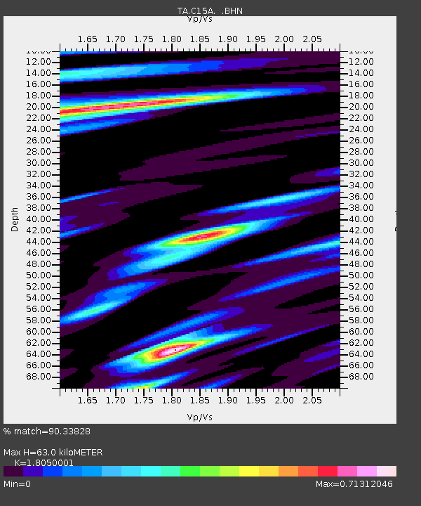
| Estimated Moho Depth: |
63.0 km |
| Estimated Crust Vp/Vs: |
1.81 |
| Assumed Crust Vp: |
6.353 km/s |
| Estimated Crust Vs: |
3.52 km/s |
| Estimated Crust Poisson's Ratio: |
0.28 |
|
| Radial Match: |
90.33828 % |
| Radial Bump: |
400 |
| Transverse Match: |
84.03127 % |
| Transverse Bump: |
400 |
| SOD ConfigId: |
2504 |
| Insert Time: |
2010-03-07 00:29:59.472 +0000 |
| GWidth: |
2.5 |
| Max Bumps: |
400 |
| Tol: |
0.001 |
|
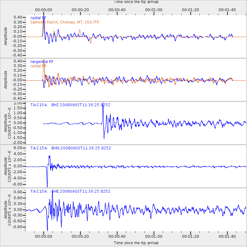
Signal To Noise
| Channel | StoN | STA | LTA |
| TA:C15A: :BHN:20080903T11:36:25.825Z | 27.575987 | 2.0336151E-6 | 7.3745866E-8 |
| TA:C15A: :BHE:20080903T11:36:25.825Z | 8.008351 | 3.921905E-7 | 4.8972684E-8 |
| TA:C15A: :BHZ:20080903T11:36:25.825Z | 12.315305 | 6.782641E-7 | 5.5074892E-8 |
| Arrivals |
| Ps | 8.1 SECOND |
| PpPs | 27 SECOND |
| PsPs/PpSs | 35 SECOND |


