You are here: Home > Network List > TA - USArray Transportable Network (new EarthScope stations) Stations List
> Station C15A Salmond Ranch, Choteau, MT, USA > Earthquake Result Viewer
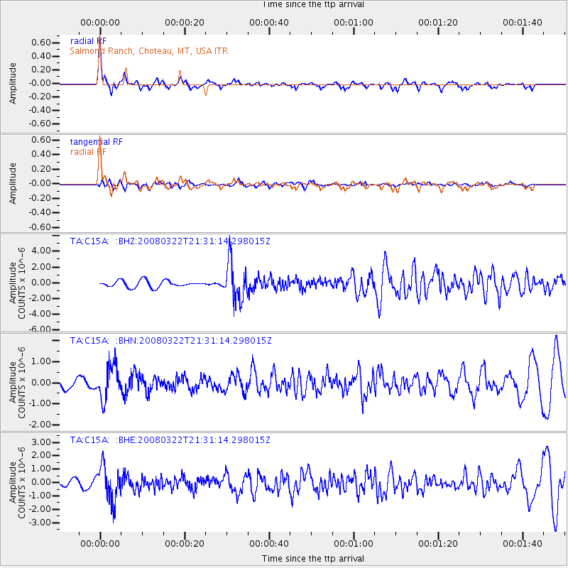
C15A Salmond Ranch, Choteau, MT, USA - Earthquake Result Viewer

| Earthquake location: |
Andreanof Islands, Aleutian Is. |
| Earthquake latitude/longitude: |
52.2/-178.7 |
| Earthquake time(UTC): |
2008/03/22 (082) 21:24:11 GMT |
| Earthquake Depth: |
132 km |
| Earthquake Magnitude: |
5.8 MB, 6.2 MW, 6.1 MW |
| Earthquake Catalog/Contributor: |
WHDF/NEIC |
|
| Network: |
TA USArray Transportable Network (new EarthScope stations) |
| Station: |
C15A Salmond Ranch, Choteau, MT, USA |
| Lat/Lon: |
47.78 N/112.61 W |
| Elevation: |
1522 m |
|
| Distance: |
41.4 deg |
| Az: |
68.786 deg |
| Baz: |
301.669 deg |
| Ray Param: |
0.07331495 |
| Estimated Moho Depth: |
47.75 km |
| Estimated Crust Vp/Vs: |
1.73 |
| Assumed Crust Vp: |
6.353 km/s |
| Estimated Crust Vs: |
3.672 km/s |
| Estimated Crust Poisson's Ratio: |
0.25 |
|
| Radial Match: |
87.062645 % |
| Radial Bump: |
304 |
| Transverse Match: |
56.140972 % |
| Transverse Bump: |
396 |
| SOD ConfigId: |
2564 |
| Insert Time: |
2010-03-07 00:30:14.913 +0000 |
| GWidth: |
2.5 |
| Max Bumps: |
400 |
| Tol: |
0.001 |
|
Signal To Noise
| Channel | StoN | STA | LTA |
| TA:C15A: :BHN:20080322T21:31:14.298015Z | 3.2065823 | 8.0150903E-7 | 2.499574E-7 |
| TA:C15A: :BHE:20080322T21:31:14.298015Z | 4.69533 | 1.290792E-6 | 2.7490975E-7 |
| TA:C15A: :BHZ:20080322T21:31:14.298015Z | 5.7157474 | 2.4359128E-6 | 4.2617575E-7 |
| Arrivals |
| Ps | 5.9 SECOND |
| PpPs | 19 SECOND |
| PsPs/PpSs | 25 SECOND |


