You are here: Home > Network List > AV - Alaska Volcano Observatory Stations List
> Station SPBL Spurr Beluga Lake, Mount Spur, Alaska > Earthquake Result Viewer
SPBL Spurr Beluga Lake, Mount Spur, Alaska - Earthquake Result Viewer
| Earthquake location: |
Banda Sea |
| Earthquake latitude/longitude: |
-6.4/129.2 |
| Earthquake time(UTC): |
2019/06/24 (175) 02:53:39 GMT |
| Earthquake Depth: |
212 km |
| Earthquake Magnitude: |
7.3 mww |
| Earthquake Catalog/Contributor: |
NEIC PDE/us |
|
| Network: |
AV Alaska Volcano Observatory |
| Station: |
SPBL Spurr Beluga Lake, Mount Spur, Alaska |
| Lat/Lon: |
61.38 N/151.89 W |
| Elevation: |
927 m |
|
| Distance: |
90.3 deg |
| Az: |
28.203 deg |
| Baz: |
257.259 deg |
| Ray Param: |
0.041636 |
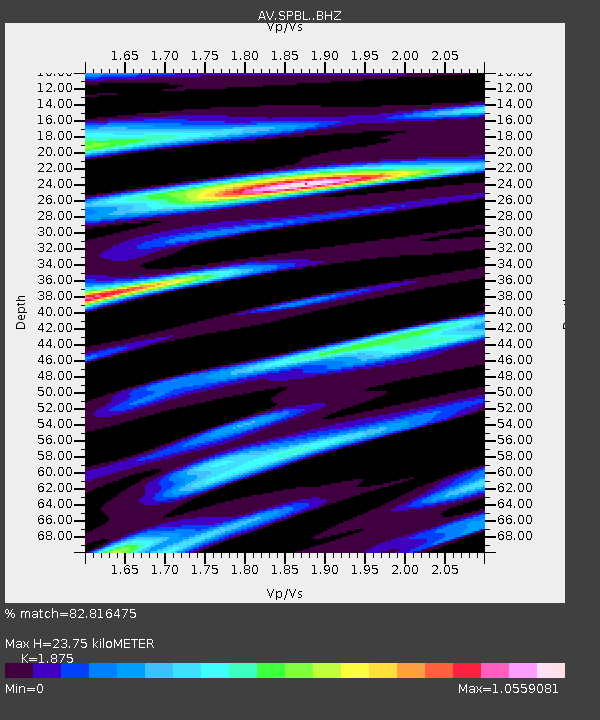
| Estimated Moho Depth: |
23.75 km |
| Estimated Crust Vp/Vs: |
1.88 |
| Assumed Crust Vp: |
6.302 km/s |
| Estimated Crust Vs: |
3.361 km/s |
| Estimated Crust Poisson's Ratio: |
0.30 |
|
| Radial Match: |
82.816475 % |
| Radial Bump: |
400 |
| Transverse Match: |
69.15967 % |
| Transverse Bump: |
400 |
| SOD ConfigId: |
18369291 |
| Insert Time: |
2019-07-08 02:55:35.148 +0000 |
| GWidth: |
2.5 |
| Max Bumps: |
400 |
| Tol: |
0.001 |
|

Signal To Noise
| Channel | StoN | STA | LTA |
| AV:SPBL: :BHZ:20190624T03:05:45.199995Z | 60.27889 | 2.7351598E-6 | 4.537509E-8 |
| AV:SPBL: :BHN:20190624T03:05:45.199995Z | 6.2640705 | 3.0081947E-7 | 4.8023E-8 |
| AV:SPBL: :BHE:20190624T03:05:45.199995Z | 7.3243885 | 5.4490687E-7 | 7.4396226E-8 |
| Arrivals |
| Ps | 3.4 SECOND |
| PpPs | 11 SECOND |
| PsPs/PpSs | 14 SECOND |


