You are here: Home > Network List > TA - USArray Transportable Network (new EarthScope stations) Stations List
> Station C15A Salmond Ranch, Choteau, MT, USA > Earthquake Result Viewer
C15A Salmond Ranch, Choteau, MT, USA - Earthquake Result Viewer
| Earthquake location: |
Near Coast Of Peru |
| Earthquake latitude/longitude: |
-15.7/-74.8 |
| Earthquake time(UTC): |
2009/05/18 (138) 14:01:04 GMT |
| Earthquake Depth: |
23 km |
| Earthquake Magnitude: |
5.5 MS, 5.3 MB, 5.8 MW, 5.8 MW |
| Earthquake Catalog/Contributor: |
WHDF/NEIC |
|
| Network: |
TA USArray Transportable Network (new EarthScope stations) |
| Station: |
C15A Salmond Ranch, Choteau, MT, USA |
| Lat/Lon: |
47.78 N/112.61 W |
| Elevation: |
1522 m |
|
| Distance: |
71.6 deg |
| Az: |
334.19 deg |
| Baz: |
141.55 deg |
| Ray Param: |
0.05419359 |
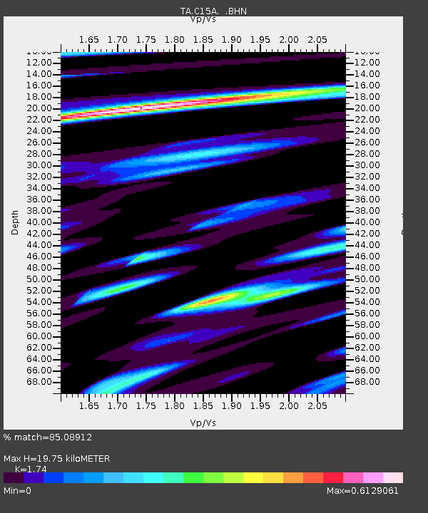
| Estimated Moho Depth: |
19.75 km |
| Estimated Crust Vp/Vs: |
1.74 |
| Assumed Crust Vp: |
6.353 km/s |
| Estimated Crust Vs: |
3.651 km/s |
| Estimated Crust Poisson's Ratio: |
0.25 |
|
| Radial Match: |
85.08912 % |
| Radial Bump: |
363 |
| Transverse Match: |
64.01043 % |
| Transverse Bump: |
400 |
| SOD ConfigId: |
2760 |
| Insert Time: |
2010-03-07 00:30:23.536 +0000 |
| GWidth: |
2.5 |
| Max Bumps: |
400 |
| Tol: |
0.001 |
|
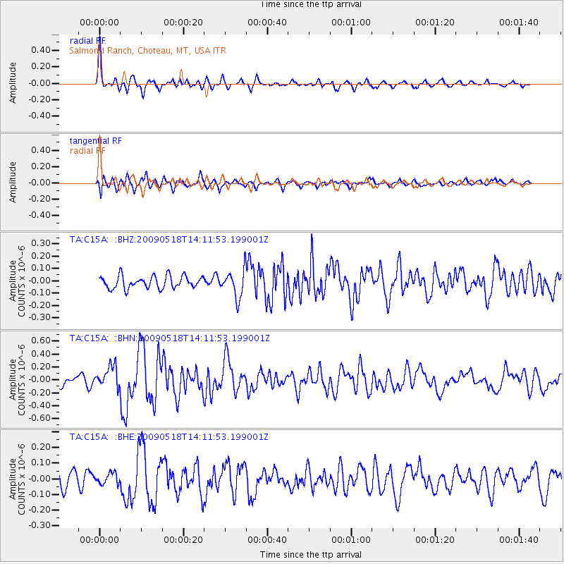
Signal To Noise
| Channel | StoN | STA | LTA |
| TA:C15A: :BHN:20090518T14:11:53.199001Z | 3.0963626 | 1.7047282E-7 | 5.505583E-8 |
| TA:C15A: :BHE:20090518T14:11:53.199001Z | 0.55739695 | 3.6526586E-8 | 6.553066E-8 |
| TA:C15A: :BHZ:20090518T14:11:53.199001Z | 2.2895694 | 1.14135325E-7 | 4.985013E-8 |
| Arrivals |
| Ps | 2.4 SECOND |
| PpPs | 8.2 SECOND |
| PsPs/PpSs | 11 SECOND |


