You are here: Home > Network List > TA - USArray Transportable Network (new EarthScope stations) Stations List
> Station C15A Salmond Ranch, Choteau, MT, USA > Earthquake Result Viewer
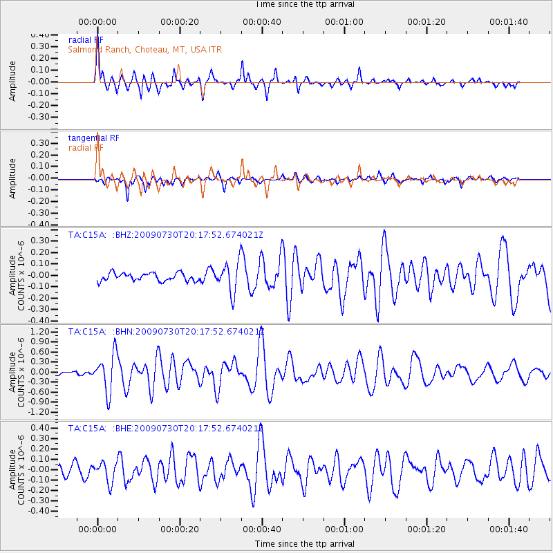
C15A Salmond Ranch, Choteau, MT, USA - Earthquake Result Viewer
| Earthquake location: |
Tonga Islands |
| Earthquake latitude/longitude: |
-20.8/-174.3 |
| Earthquake time(UTC): |
2009/07/30 (211) 20:05:34 GMT |
| Earthquake Depth: |
10 km |
| Earthquake Magnitude: |
5.9 MB, 5.7 MS, 5.8 MW, 5.7 MW |
| Earthquake Catalog/Contributor: |
WHDF/NEIC |
|
| Network: |
TA USArray Transportable Network (new EarthScope stations) |
| Station: |
C15A Salmond Ranch, Choteau, MT, USA |
| Lat/Lon: |
47.78 N/112.61 W |
| Elevation: |
1522 m |
|
| Distance: |
87.8 deg |
| Az: |
36.444 deg |
| Baz: |
235.458 deg |
| Ray Param: |
0.04306225 |
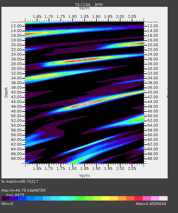
| Estimated Moho Depth: |
44.75 km |
| Estimated Crust Vp/Vs: |
1.85 |
| Assumed Crust Vp: |
6.353 km/s |
| Estimated Crust Vs: |
3.439 km/s |
| Estimated Crust Poisson's Ratio: |
0.29 |
|
| Radial Match: |
89.70217 % |
| Radial Bump: |
360 |
| Transverse Match: |
80.891426 % |
| Transverse Bump: |
377 |
| SOD ConfigId: |
2622 |
| Insert Time: |
2010-03-07 00:30:25.252 +0000 |
| GWidth: |
2.5 |
| Max Bumps: |
400 |
| Tol: |
0.001 |
|
Signal To Noise
| Channel | StoN | STA | LTA |
| TA:C15A: :BHN:20090730T20:17:52.674021Z | 17.328293 | 5.8226436E-7 | 3.3601946E-8 |
| TA:C15A: :BHE:20090730T20:17:52.674021Z | 1.7342062 | 9.851666E-8 | 5.6807924E-8 |
| TA:C15A: :BHZ:20090730T20:17:52.674021Z | 4.050759 | 1.3935839E-7 | 3.4403033E-8 |
| Arrivals |
| Ps | 6.1 SECOND |
| PpPs | 20 SECOND |
| PsPs/PpSs | 26 SECOND |


