You are here: Home > Network List > TA - USArray Transportable Network (new EarthScope stations) Stations List
> Station C15A Salmond Ranch, Choteau, MT, USA > Earthquake Result Viewer
C15A Salmond Ranch, Choteau, MT, USA - Earthquake Result Viewer
| Earthquake location: |
Near S. Coast Of Honshu, Japan |
| Earthquake latitude/longitude: |
33.2/137.9 |
| Earthquake time(UTC): |
2009/08/09 (221) 10:55:55 GMT |
| Earthquake Depth: |
297 km |
| Earthquake Magnitude: |
6.5 MB, 7.1 MW, 7.1 MW |
| Earthquake Catalog/Contributor: |
WHDF/NEIC |
|
| Network: |
TA USArray Transportable Network (new EarthScope stations) |
| Station: |
C15A Salmond Ranch, Choteau, MT, USA |
| Lat/Lon: |
47.78 N/112.61 W |
| Elevation: |
1522 m |
|
| Distance: |
77.7 deg |
| Az: |
40.62 deg |
| Baz: |
305.947 deg |
| Ray Param: |
0.049360663 |
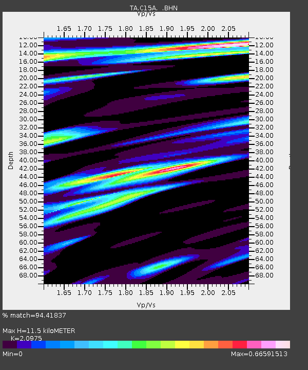
| Estimated Moho Depth: |
11.5 km |
| Estimated Crust Vp/Vs: |
2.10 |
| Assumed Crust Vp: |
6.353 km/s |
| Estimated Crust Vs: |
3.029 km/s |
| Estimated Crust Poisson's Ratio: |
0.35 |
|
| Radial Match: |
94.41837 % |
| Radial Bump: |
400 |
| Transverse Match: |
86.52115 % |
| Transverse Bump: |
400 |
| SOD ConfigId: |
2622 |
| Insert Time: |
2010-03-07 00:30:27.161 +0000 |
| GWidth: |
2.5 |
| Max Bumps: |
400 |
| Tol: |
0.001 |
|
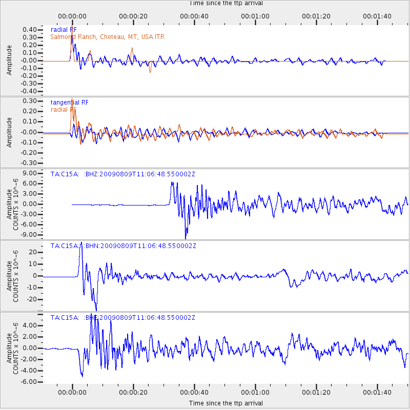
Signal To Noise
| Channel | StoN | STA | LTA |
| TA:C15A: :BHN:20090809T11:06:48.550002Z | 118.33981 | 1.1935973E-5 | 1.00861854E-7 |
| TA:C15A: :BHE:20090809T11:06:48.550002Z | 33.82072 | 1.9662607E-6 | 5.8137754E-8 |
| TA:C15A: :BHZ:20090809T11:06:48.550002Z | 43.296524 | 2.9996659E-6 | 6.928191E-8 |
| Arrivals |
| Ps | 2.0 SECOND |
| PpPs | 5.5 SECOND |
| PsPs/PpSs | 7.5 SECOND |


