You are here: Home > Network List > G - GEOSCOPE Stations List
> Station SANVU Espiritu Santo, Vanuatu > Earthquake Result Viewer
SANVU Espiritu Santo, Vanuatu - Earthquake Result Viewer
| Earthquake location: |
Banda Sea |
| Earthquake latitude/longitude: |
-6.4/129.2 |
| Earthquake time(UTC): |
2019/06/24 (175) 02:53:39 GMT |
| Earthquake Depth: |
212 km |
| Earthquake Magnitude: |
7.3 mww |
| Earthquake Catalog/Contributor: |
NEIC PDE/us |
|
| Network: |
G GEOSCOPE |
| Station: |
SANVU Espiritu Santo, Vanuatu |
| Lat/Lon: |
15.45 S/167.20 E |
| Elevation: |
56 m |
|
| Distance: |
38.4 deg |
| Az: |
106.753 deg |
| Baz: |
279.301 deg |
| Ray Param: |
0.074802615 |
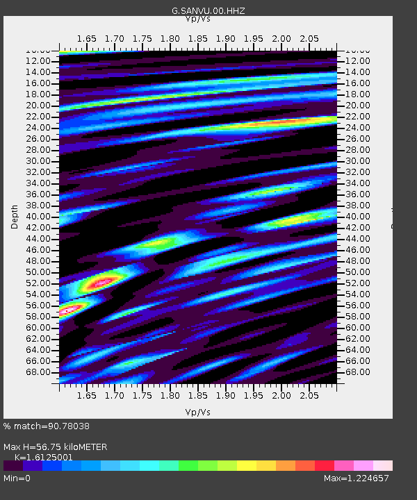
| Estimated Moho Depth: |
56.75 km |
| Estimated Crust Vp/Vs: |
1.61 |
| Assumed Crust Vp: |
4.802 km/s |
| Estimated Crust Vs: |
2.978 km/s |
| Estimated Crust Poisson's Ratio: |
0.19 |
|
| Radial Match: |
90.78038 % |
| Radial Bump: |
400 |
| Transverse Match: |
72.45988 % |
| Transverse Bump: |
400 |
| SOD ConfigId: |
18369291 |
| Insert Time: |
2019-07-08 02:56:00.550 +0000 |
| GWidth: |
2.5 |
| Max Bumps: |
400 |
| Tol: |
0.001 |
|

Signal To Noise
| Channel | StoN | STA | LTA |
| G:SANVU:00:HHZ:20190624T03:00:09.729994Z | 211.71889 | 5.9904825E-5 | 2.829451E-7 |
| G:SANVU:00:HHN:20190624T03:00:09.729994Z | 27.544884 | 6.564391E-6 | 2.3831616E-7 |
| G:SANVU:00:HHE:20190624T03:00:09.729994Z | 150.64752 | 3.1514843E-5 | 2.0919592E-7 |
| Arrivals |
| Ps | 7.5 SECOND |
| PpPs | 30 SECOND |
| PsPs/PpSs | 37 SECOND |


