You are here: Home > Network List > TA - USArray Transportable Network (new EarthScope stations) Stations List
> Station C15A Salmond Ranch, Choteau, MT, USA > Earthquake Result Viewer
C15A Salmond Ranch, Choteau, MT, USA - Earthquake Result Viewer
| Earthquake location: |
Andreanof Islands, Aleutian Is. |
| Earthquake latitude/longitude: |
51.5/-178.3 |
| Earthquake time(UTC): |
2009/03/30 (089) 12:07:28 GMT |
| Earthquake Depth: |
31 km |
| Earthquake Magnitude: |
6.0 MB, 5.5 MS, 5.7 MW, 5.7 MW |
| Earthquake Catalog/Contributor: |
WHDF/NEIC |
|
| Network: |
TA USArray Transportable Network (new EarthScope stations) |
| Station: |
C15A Salmond Ranch, Choteau, MT, USA |
| Lat/Lon: |
47.78 N/112.61 W |
| Elevation: |
1522 m |
|
| Distance: |
41.4 deg |
| Az: |
68.349 deg |
| Baz: |
300.609 deg |
| Ray Param: |
0.07376192 |
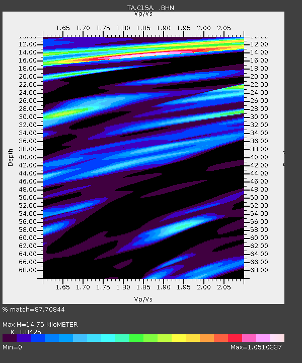
| Estimated Moho Depth: |
14.75 km |
| Estimated Crust Vp/Vs: |
1.84 |
| Assumed Crust Vp: |
6.353 km/s |
| Estimated Crust Vs: |
3.448 km/s |
| Estimated Crust Poisson's Ratio: |
0.29 |
|
| Radial Match: |
87.70844 % |
| Radial Bump: |
400 |
| Transverse Match: |
76.28808 % |
| Transverse Bump: |
400 |
| SOD ConfigId: |
2658 |
| Insert Time: |
2010-03-07 00:31:01.336 +0000 |
| GWidth: |
2.5 |
| Max Bumps: |
400 |
| Tol: |
0.001 |
|
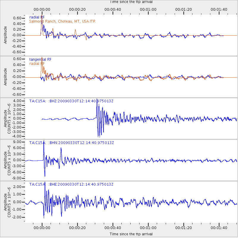
Signal To Noise
| Channel | StoN | STA | LTA |
| TA:C15A: :BHN:20090330T12:14:40.975013Z | 13.958735 | 2.7684598E-6 | 1.9833172E-7 |
| TA:C15A: :BHE:20090330T12:14:40.975013Z | 6.13546 | 9.3952315E-7 | 1.5313003E-7 |
| TA:C15A: :BHZ:20090330T12:14:40.975013Z | 17.64706 | 1.9940067E-6 | 1.1299371E-7 |
| Arrivals |
| Ps | 2.1 SECOND |
| PpPs | 6.2 SECOND |
| PsPs/PpSs | 8.3 SECOND |


