You are here: Home > Network List > TA - USArray Transportable Network (new EarthScope stations) Stations List
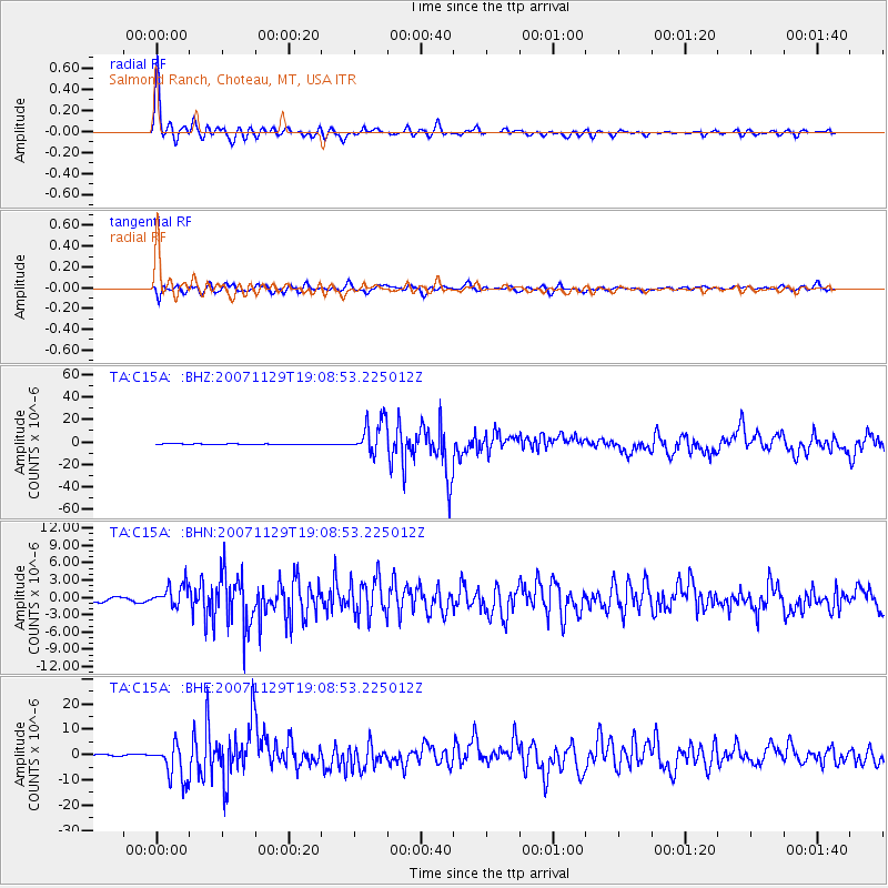
> Station C15A Salmond Ranch, Choteau, MT, USA > Earthquake Result Viewer
C15A Salmond Ranch, Choteau, MT, USA - Earthquake Result Viewer
| Earthquake location: |
Windward Islands |
| Earthquake latitude/longitude: |
15.0/-61.3 |
| Earthquake time(UTC): |
2007/11/29 (333) 19:00:19 GMT |
| Earthquake Depth: |
148 km |
| Earthquake Magnitude: |
6.9 MB, 7.4 MW, 7.4 MW |
| Earthquake Catalog/Contributor: |
WHDF/NEIC |
|
| Network: |
TA USArray Transportable Network (new EarthScope stations) |
| Station: |
C15A Salmond Ranch, Choteau, MT, USA |
| Lat/Lon: |
47.78 N/112.61 W |
| Elevation: |
1522 m |
|
| Distance: |
53.4 deg |
| Az: |
318.972 deg |
| Baz: |
109.853 deg |
| Ray Param: |
0.0656487 |
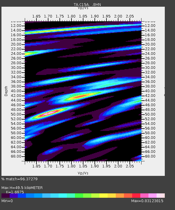
| Estimated Moho Depth: |
49.5 km |
| Estimated Crust Vp/Vs: |
1.70 |
| Assumed Crust Vp: |
6.353 km/s |
| Estimated Crust Vs: |
3.743 km/s |
| Estimated Crust Poisson's Ratio: |
0.23 |
|
| Radial Match: |
96.37279 % |
| Radial Bump: |
400 |
| Transverse Match: |
90.11489 % |
| Transverse Bump: |
400 |
| SOD ConfigId: |
2564 |
| Insert Time: |
2010-03-07 00:31:19.319 +0000 |
| GWidth: |
2.5 |
| Max Bumps: |
400 |
| Tol: |
0.001 |
|
Signal To Noise
| Channel | StoN | STA | LTA |
| TA:C15A: :BHN:20071129T19:08:53.225012Z | 6.7878456 | 1.8430828E-6 | 2.7152691E-7 |
| TA:C15A: :BHE:20071129T19:08:53.225012Z | 29.563723 | 7.12783E-6 | 2.4110057E-7 |
| TA:C15A: :BHZ:20071129T19:08:53.225012Z | 60.587788 | 1.4926314E-5 | 2.4635847E-7 |
| Arrivals |
| Ps | 5.7 SECOND |
| PpPs | 20 SECOND |
| PsPs/PpSs | 26 SECOND |


