You are here: Home > Network List > TA - USArray Transportable Network (new EarthScope stations) Stations List
> Station B18K Kokolik River, AK, USA > Earthquake Result Viewer
B18K Kokolik River, AK, USA - Earthquake Result Viewer
| Earthquake location: |
Banda Sea |
| Earthquake latitude/longitude: |
-6.4/129.2 |
| Earthquake time(UTC): |
2019/06/24 (175) 02:53:39 GMT |
| Earthquake Depth: |
212 km |
| Earthquake Magnitude: |
7.3 mww |
| Earthquake Catalog/Contributor: |
NEIC PDE/us |
|
| Network: |
TA USArray Transportable Network (new EarthScope stations) |
| Station: |
B18K Kokolik River, AK, USA |
| Lat/Lon: |
69.36 N/161.80 W |
| Elevation: |
222 m |
|
| Distance: |
88.7 deg |
| Az: |
19.336 deg |
| Baz: |
248.162 deg |
| Ray Param: |
0.041895058 |
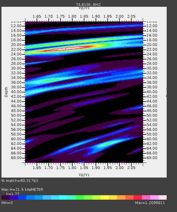
| Estimated Moho Depth: |
21.5 km |
| Estimated Crust Vp/Vs: |
1.77 |
| Assumed Crust Vp: |
5.906 km/s |
| Estimated Crust Vs: |
3.337 km/s |
| Estimated Crust Poisson's Ratio: |
0.27 |
|
| Radial Match: |
90.31763 % |
| Radial Bump: |
400 |
| Transverse Match: |
81.5079 % |
| Transverse Bump: |
400 |
| SOD ConfigId: |
18369291 |
| Insert Time: |
2019-07-08 02:57:42.222 +0000 |
| GWidth: |
2.5 |
| Max Bumps: |
400 |
| Tol: |
0.001 |
|
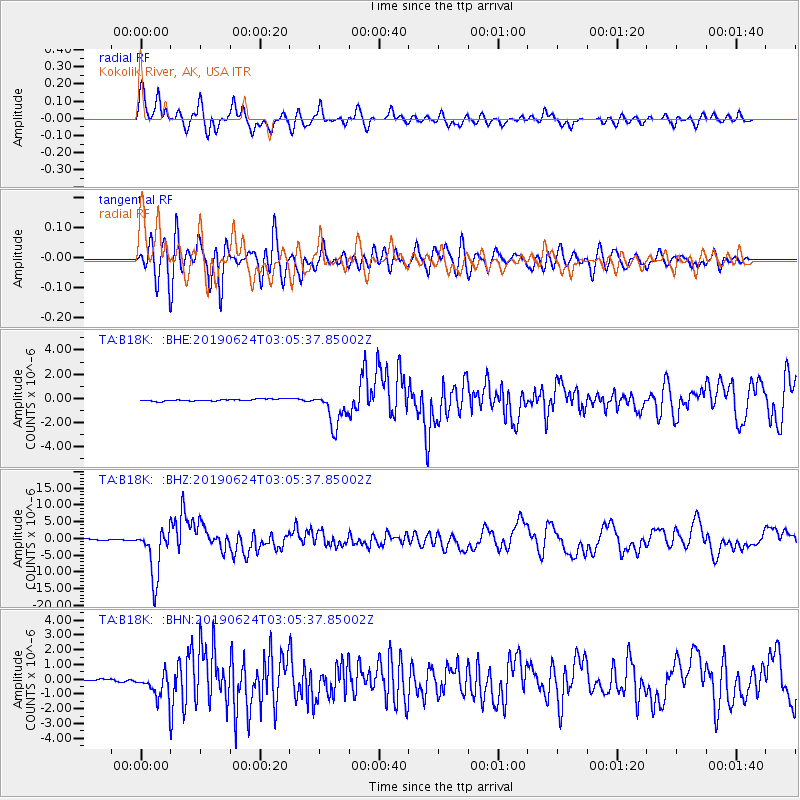
Signal To Noise
| Channel | StoN | STA | LTA |
| TA:B18K: :BHZ:20190624T03:05:37.85002Z | 54.749187 | 7.4303184E-6 | 1.357156E-7 |
| TA:B18K: :BHN:20190624T03:05:37.85002Z | 10.922016 | 8.429763E-7 | 7.7181376E-8 |
| TA:B18K: :BHE:20190624T03:05:37.85002Z | 18.009422 | 1.4575587E-6 | 8.093312E-8 |
| Arrivals |
| Ps | 2.9 SECOND |
| PpPs | 9.9 SECOND |
| PsPs/PpSs | 13 SECOND |


