You are here: Home > Network List > TA - USArray Transportable Network (new EarthScope stations) Stations List
> Station E17K Hotham Inlet, AK, USA > Earthquake Result Viewer
E17K Hotham Inlet, AK, USA - Earthquake Result Viewer
| Earthquake location: |
Banda Sea |
| Earthquake latitude/longitude: |
-6.4/129.2 |
| Earthquake time(UTC): |
2019/06/24 (175) 02:53:39 GMT |
| Earthquake Depth: |
212 km |
| Earthquake Magnitude: |
7.3 mww |
| Earthquake Catalog/Contributor: |
NEIC PDE/us |
|
| Network: |
TA USArray Transportable Network (new EarthScope stations) |
| Station: |
E17K Hotham Inlet, AK, USA |
| Lat/Lon: |
67.08 N/161.83 W |
| Elevation: |
233 m |
|
| Distance: |
87.9 deg |
| Az: |
21.462 deg |
| Baz: |
248.203 deg |
| Ray Param: |
0.042520735 |
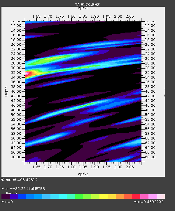
| Estimated Moho Depth: |
32.25 km |
| Estimated Crust Vp/Vs: |
1.60 |
| Assumed Crust Vp: |
6.276 km/s |
| Estimated Crust Vs: |
3.922 km/s |
| Estimated Crust Poisson's Ratio: |
0.18 |
|
| Radial Match: |
96.47517 % |
| Radial Bump: |
346 |
| Transverse Match: |
89.10718 % |
| Transverse Bump: |
400 |
| SOD ConfigId: |
18369291 |
| Insert Time: |
2019-07-08 02:57:56.782 +0000 |
| GWidth: |
2.5 |
| Max Bumps: |
400 |
| Tol: |
0.001 |
|

Signal To Noise
| Channel | StoN | STA | LTA |
| TA:E17K: :BHZ:20190624T03:05:33.799971Z | 66.72862 | 7.2403163E-6 | 1.08503905E-7 |
| TA:E17K: :BHN:20190624T03:05:33.799971Z | 21.55055 | 1.1285133E-6 | 5.236587E-8 |
| TA:E17K: :BHE:20190624T03:05:33.799971Z | 21.056385 | 2.1037793E-6 | 9.99117E-8 |
| Arrivals |
| Ps | 3.2 SECOND |
| PpPs | 13 SECOND |
| PsPs/PpSs | 16 SECOND |


