You are here: Home > Network List > TA - USArray Transportable Network (new EarthScope stations) Stations List
> Station E20K Nigu River, AK, USA > Earthquake Result Viewer
E20K Nigu River, AK, USA - Earthquake Result Viewer
| Earthquake location: |
Banda Sea |
| Earthquake latitude/longitude: |
-6.4/129.2 |
| Earthquake time(UTC): |
2019/06/24 (175) 02:53:39 GMT |
| Earthquake Depth: |
212 km |
| Earthquake Magnitude: |
7.3 mww |
| Earthquake Catalog/Contributor: |
NEIC PDE/us |
|
| Network: |
TA USArray Transportable Network (new EarthScope stations) |
| Station: |
E20K Nigu River, AK, USA |
| Lat/Lon: |
68.26 N/156.19 W |
| Elevation: |
866 m |
|
| Distance: |
90.3 deg |
| Az: |
21.056 deg |
| Baz: |
253.407 deg |
| Ray Param: |
0.041638095 |
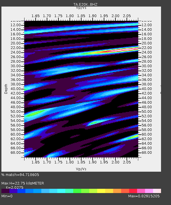
| Estimated Moho Depth: |
22.75 km |
| Estimated Crust Vp/Vs: |
2.03 |
| Assumed Crust Vp: |
6.221 km/s |
| Estimated Crust Vs: |
3.068 km/s |
| Estimated Crust Poisson's Ratio: |
0.34 |
|
| Radial Match: |
94.718605 % |
| Radial Bump: |
400 |
| Transverse Match: |
81.79441 % |
| Transverse Bump: |
400 |
| SOD ConfigId: |
18369291 |
| Insert Time: |
2019-07-08 02:57:59.758 +0000 |
| GWidth: |
2.5 |
| Max Bumps: |
400 |
| Tol: |
0.001 |
|
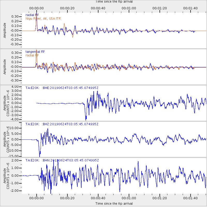
Signal To Noise
| Channel | StoN | STA | LTA |
| TA:E20K: :BHZ:20190624T03:05:45.074995Z | 68.398834 | 5.677201E-6 | 8.300143E-8 |
| TA:E20K: :BHN:20190624T03:05:45.074995Z | 6.065259 | 3.7878388E-7 | 6.245139E-8 |
| TA:E20K: :BHE:20190624T03:05:45.074995Z | 35.57249 | 1.6039712E-6 | 4.5090214E-8 |
| Arrivals |
| Ps | 3.8 SECOND |
| PpPs | 11 SECOND |
| PsPs/PpSs | 15 SECOND |


