You are here: Home > Network List > TA - USArray Transportable Network (new EarthScope stations) Stations List
> Station H20K Anotleneega Mountain, AK, USA > Earthquake Result Viewer
H20K Anotleneega Mountain, AK, USA - Earthquake Result Viewer
| Earthquake location: |
Banda Sea |
| Earthquake latitude/longitude: |
-6.4/129.2 |
| Earthquake time(UTC): |
2019/06/24 (175) 02:53:39 GMT |
| Earthquake Depth: |
212 km |
| Earthquake Magnitude: |
7.3 mww |
| Earthquake Catalog/Contributor: |
NEIC PDE/us |
|
| Network: |
TA USArray Transportable Network (new EarthScope stations) |
| Station: |
H20K Anotleneega Mountain, AK, USA |
| Lat/Lon: |
65.49 N/154.88 W |
| Elevation: |
514 m |
|
| Distance: |
90.0 deg |
| Az: |
23.869 deg |
| Baz: |
254.602 deg |
| Ray Param: |
0.041657254 |
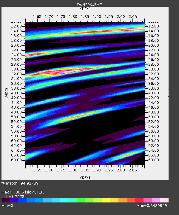
| Estimated Moho Depth: |
30.5 km |
| Estimated Crust Vp/Vs: |
1.80 |
| Assumed Crust Vp: |
6.566 km/s |
| Estimated Crust Vs: |
3.653 km/s |
| Estimated Crust Poisson's Ratio: |
0.28 |
|
| Radial Match: |
94.92739 % |
| Radial Bump: |
384 |
| Transverse Match: |
84.730774 % |
| Transverse Bump: |
400 |
| SOD ConfigId: |
18369291 |
| Insert Time: |
2019-07-08 02:58:24.799 +0000 |
| GWidth: |
2.5 |
| Max Bumps: |
400 |
| Tol: |
0.001 |
|

Signal To Noise
| Channel | StoN | STA | LTA |
| TA:H20K: :BHZ:20190624T03:05:43.824995Z | 51.723324 | 4.7757153E-6 | 9.2331945E-8 |
| TA:H20K: :BHN:20190624T03:05:43.824995Z | 11.401883 | 4.4779384E-7 | 3.9273676E-8 |
| TA:H20K: :BHE:20190624T03:05:43.824995Z | 29.272865 | 1.5364701E-6 | 5.2487863E-8 |
| Arrivals |
| Ps | 3.8 SECOND |
| PpPs | 13 SECOND |
| PsPs/PpSs | 17 SECOND |


