You are here: Home > Network List > TA - USArray Transportable Network (new EarthScope stations) Stations List
> Station C15A Salmond Ranch, Choteau, MT, USA > Earthquake Result Viewer
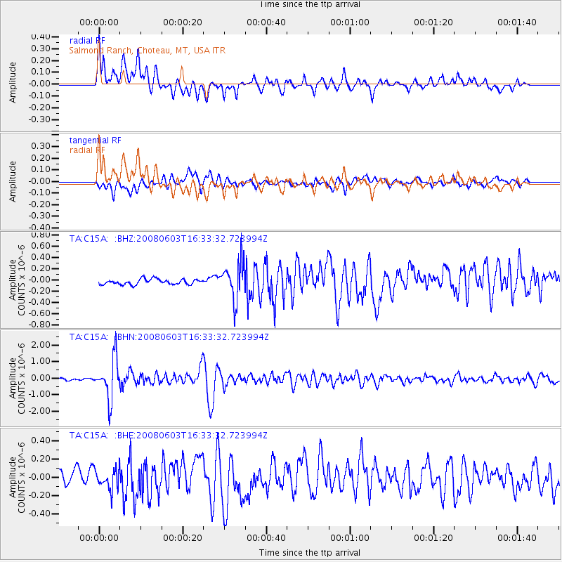
C15A Salmond Ranch, Choteau, MT, USA - Earthquake Result Viewer
| Earthquake location: |
Solomon Islands |
| Earthquake latitude/longitude: |
-10.5/161.3 |
| Earthquake time(UTC): |
2008/06/03 (155) 16:20:50 GMT |
| Earthquake Depth: |
84 km |
| Earthquake Magnitude: |
6.2 MB, 6.2 MW, 6.2 MW |
| Earthquake Catalog/Contributor: |
WHDF/NEIC |
|
| Network: |
TA USArray Transportable Network (new EarthScope stations) |
| Station: |
C15A Salmond Ranch, Choteau, MT, USA |
| Lat/Lon: |
47.78 N/112.61 W |
| Elevation: |
1522 m |
|
| Distance: |
95.1 deg |
| Az: |
42.504 deg |
| Baz: |
260.093 deg |
| Ray Param: |
0.040814877 |
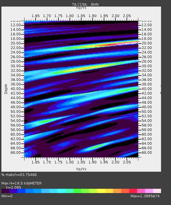
| Estimated Moho Depth: |
19.5 km |
| Estimated Crust Vp/Vs: |
2.10 |
| Assumed Crust Vp: |
6.353 km/s |
| Estimated Crust Vs: |
3.032 km/s |
| Estimated Crust Poisson's Ratio: |
0.35 |
|
| Radial Match: |
83.75468 % |
| Radial Bump: |
400 |
| Transverse Match: |
82.38025 % |
| Transverse Bump: |
400 |
| SOD ConfigId: |
2504 |
| Insert Time: |
2010-03-07 00:31:52.301 +0000 |
| GWidth: |
2.5 |
| Max Bumps: |
400 |
| Tol: |
0.001 |
|
Signal To Noise
| Channel | StoN | STA | LTA |
| TA:C15A: :BHN:20080603T16:33:32.723994Z | 20.196245 | 1.2514893E-6 | 6.196644E-8 |
| TA:C15A: :BHE:20080603T16:33:32.723994Z | 1.6267756 | 1.0649958E-7 | 6.5466665E-8 |
| TA:C15A: :BHZ:20080603T16:33:32.723994Z | 7.1878853 | 3.379545E-7 | 4.7017238E-8 |
| Arrivals |
| Ps | 3.4 SECOND |
| PpPs | 9.3 SECOND |
| PsPs/PpSs | 13 SECOND |


