You are here: Home > Network List > TA - USArray Transportable Network (new EarthScope stations) Stations List
> Station H27K Steamboat Mountain, AK, USA > Earthquake Result Viewer
H27K Steamboat Mountain, AK, USA - Earthquake Result Viewer
| Earthquake location: |
Banda Sea |
| Earthquake latitude/longitude: |
-6.4/129.2 |
| Earthquake time(UTC): |
2019/06/24 (175) 02:53:39 GMT |
| Earthquake Depth: |
212 km |
| Earthquake Magnitude: |
7.3 mww |
| Earthquake Catalog/Contributor: |
NEIC PDE/us |
|
| Network: |
TA USArray Transportable Network (new EarthScope stations) |
| Station: |
H27K Steamboat Mountain, AK, USA |
| Lat/Lon: |
66.23 N/141.53 W |
| Elevation: |
786 m |
|
| Distance: |
95.5 deg |
| Az: |
24.029 deg |
| Baz: |
266.776 deg |
| Ray Param: |
0.04058702 |
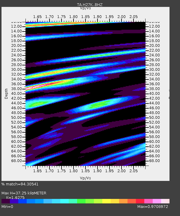
| Estimated Moho Depth: |
37.25 km |
| Estimated Crust Vp/Vs: |
1.63 |
| Assumed Crust Vp: |
6.577 km/s |
| Estimated Crust Vs: |
4.041 km/s |
| Estimated Crust Poisson's Ratio: |
0.20 |
|
| Radial Match: |
94.30541 % |
| Radial Bump: |
397 |
| Transverse Match: |
92.12986 % |
| Transverse Bump: |
400 |
| SOD ConfigId: |
18369291 |
| Insert Time: |
2019-07-08 02:58:29.116 +0000 |
| GWidth: |
2.5 |
| Max Bumps: |
400 |
| Tol: |
0.001 |
|

Signal To Noise
| Channel | StoN | STA | LTA |
| TA:H27K: :BHZ:20190624T03:06:09.124983Z | 60.759754 | 5.147175E-6 | 8.471356E-8 |
| TA:H27K: :BHN:20190624T03:06:09.124983Z | 14.778737 | 7.7260967E-7 | 5.2278462E-8 |
| TA:H27K: :BHE:20190624T03:06:09.124983Z | 24.501095 | 1.788867E-6 | 7.301172E-8 |
| Arrivals |
| Ps | 3.6 SECOND |
| PpPs | 15 SECOND |
| PsPs/PpSs | 18 SECOND |


