You are here: Home > Network List > TA - USArray Transportable Network (new EarthScope stations) Stations List
> Station C15A Salmond Ranch, Choteau, MT, USA > Earthquake Result Viewer
C15A Salmond Ranch, Choteau, MT, USA - Earthquake Result Viewer
| Earthquake location: |
Sea Of Okhotsk |
| Earthquake latitude/longitude: |
53.9/152.9 |
| Earthquake time(UTC): |
2008/07/05 (187) 02:12:04 GMT |
| Earthquake Depth: |
633 km |
| Earthquake Magnitude: |
6.8 MB, 7.7 MW, 7.7 MW |
| Earthquake Catalog/Contributor: |
WHDF/NEIC |
|
| Network: |
TA USArray Transportable Network (new EarthScope stations) |
| Station: |
C15A Salmond Ranch, Choteau, MT, USA |
| Lat/Lon: |
47.78 N/112.61 W |
| Elevation: |
1522 m |
|
| Distance: |
55.7 deg |
| Az: |
54.492 deg |
| Baz: |
314.399 deg |
| Ray Param: |
0.061858743 |
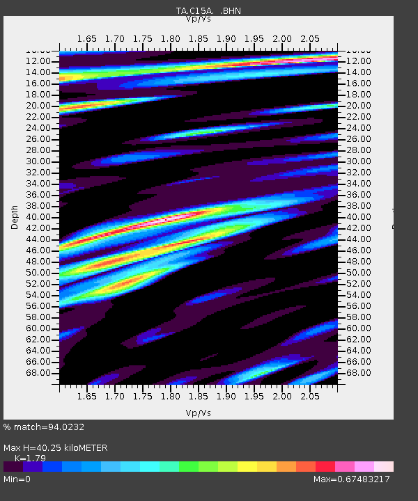
| Estimated Moho Depth: |
40.25 km |
| Estimated Crust Vp/Vs: |
1.79 |
| Assumed Crust Vp: |
6.353 km/s |
| Estimated Crust Vs: |
3.549 km/s |
| Estimated Crust Poisson's Ratio: |
0.27 |
|
| Radial Match: |
94.0232 % |
| Radial Bump: |
400 |
| Transverse Match: |
88.47204 % |
| Transverse Bump: |
400 |
| SOD ConfigId: |
2504 |
| Insert Time: |
2010-03-07 00:32:02.814 +0000 |
| GWidth: |
2.5 |
| Max Bumps: |
400 |
| Tol: |
0.001 |
|
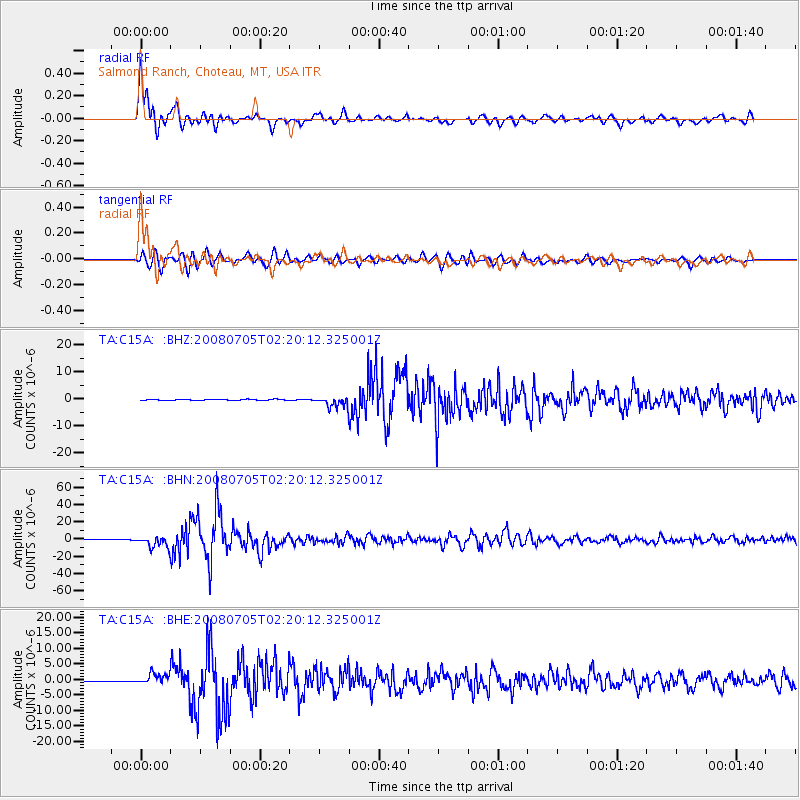
Signal To Noise
| Channel | StoN | STA | LTA |
| TA:C15A: :BHN:20080705T02:20:12.325001Z | 43.747528 | 6.5975364E-6 | 1.5080936E-7 |
| TA:C15A: :BHE:20080705T02:20:12.325001Z | 15.297766 | 1.7315065E-6 | 1.1318689E-7 |
| TA:C15A: :BHZ:20080705T02:20:12.325001Z | 12.309035 | 1.9491815E-6 | 1.5835373E-7 |
| Arrivals |
| Ps | 5.2 SECOND |
| PpPs | 17 SECOND |
| PsPs/PpSs | 22 SECOND |


