You are here: Home > Network List > TA - USArray Transportable Network (new EarthScope stations) Stations List
> Station L17K Donlin, AK, USA > Earthquake Result Viewer
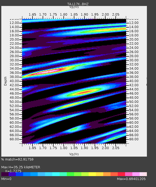
L17K Donlin, AK, USA - Earthquake Result Viewer
| Earthquake location: |
Banda Sea |
| Earthquake latitude/longitude: |
-6.4/129.2 |
| Earthquake time(UTC): |
2019/06/24 (175) 02:53:39 GMT |
| Earthquake Depth: |
212 km |
| Earthquake Magnitude: |
7.3 mww |
| Earthquake Catalog/Contributor: |
NEIC PDE/us |
|
| Network: |
TA USArray Transportable Network (new EarthScope stations) |
| Station: |
L17K Donlin, AK, USA |
| Lat/Lon: |
62.13 N/158.30 W |
| Elevation: |
338 m |
|
| Distance: |
87.6 deg |
| Az: |
26.653 deg |
| Baz: |
251.597 deg |
| Ray Param: |
0.042724498 |
| Estimated Moho Depth: |
35.25 km |
| Estimated Crust Vp/Vs: |
1.73 |
| Assumed Crust Vp: |
6.276 km/s |
| Estimated Crust Vs: |
3.633 km/s |
| Estimated Crust Poisson's Ratio: |
0.25 |
|
| Radial Match: |
92.91759 % |
| Radial Bump: |
400 |
| Transverse Match: |
78.556625 % |
| Transverse Bump: |
400 |
| SOD ConfigId: |
18369291 |
| Insert Time: |
2019-07-08 02:58:49.211 +0000 |
| GWidth: |
2.5 |
| Max Bumps: |
400 |
| Tol: |
0.001 |
|

Signal To Noise
| Channel | StoN | STA | LTA |
| TA:L17K: :BHZ:20190624T03:05:32.499983Z | 99.27607 | 1.0485986E-5 | 1.05624515E-7 |
| TA:L17K: :BHN:20190624T03:05:32.499983Z | 19.548157 | 1.2008559E-6 | 6.143065E-8 |
| TA:L17K: :BHE:20190624T03:05:32.499983Z | 38.97971 | 3.2949517E-6 | 8.452992E-8 |
| Arrivals |
| Ps | 4.2 SECOND |
| PpPs | 15 SECOND |
| PsPs/PpSs | 19 SECOND |


