You are here: Home > Network List > TA - USArray Transportable Network (new EarthScope stations) Stations List
> Station M26K Nabesna, AK, USA > Earthquake Result Viewer
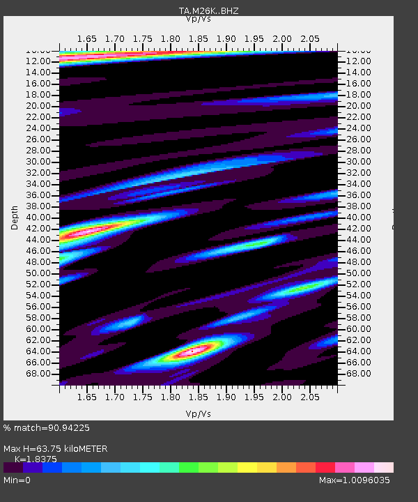
M26K Nabesna, AK, USA - Earthquake Result Viewer
| Earthquake location: |
Banda Sea |
| Earthquake latitude/longitude: |
-6.4/129.2 |
| Earthquake time(UTC): |
2019/06/24 (175) 02:53:39 GMT |
| Earthquake Depth: |
212 km |
| Earthquake Magnitude: |
7.3 mww |
| Earthquake Catalog/Contributor: |
NEIC PDE/us |
|
| Network: |
TA USArray Transportable Network (new EarthScope stations) |
| Station: |
M26K Nabesna, AK, USA |
| Lat/Lon: |
62.40 N/143.00 W |
| Elevation: |
888 m |
|
| Distance: |
94.6 deg |
| Az: |
27.834 deg |
| Baz: |
265.116 deg |
| Ray Param: |
0.040827863 |
| Estimated Moho Depth: |
63.75 km |
| Estimated Crust Vp/Vs: |
1.84 |
| Assumed Crust Vp: |
6.566 km/s |
| Estimated Crust Vs: |
3.573 km/s |
| Estimated Crust Poisson's Ratio: |
0.29 |
|
| Radial Match: |
90.94225 % |
| Radial Bump: |
400 |
| Transverse Match: |
83.29894 % |
| Transverse Bump: |
400 |
| SOD ConfigId: |
18369291 |
| Insert Time: |
2019-07-08 02:58:59.691 +0000 |
| GWidth: |
2.5 |
| Max Bumps: |
400 |
| Tol: |
0.001 |
|

Signal To Noise
| Channel | StoN | STA | LTA |
| TA:M26K: :BHZ:20190624T03:06:04.999983Z | 37.477047 | 3.0182691E-6 | 8.053647E-8 |
| TA:M26K: :BHN:20190624T03:06:04.999983Z | 3.869842 | 2.844864E-7 | 7.351369E-8 |
| TA:M26K: :BHE:20190624T03:06:04.999983Z | 11.738656 | 1.044677E-6 | 8.89946E-8 |
| Arrivals |
| Ps | 8.3 SECOND |
| PpPs | 27 SECOND |
| PsPs/PpSs | 35 SECOND |


