You are here: Home > Network List > UU - University of Utah Regional Network Stations List
> Station FORU South Mineral Mountains, UT, USA > Earthquake Result Viewer
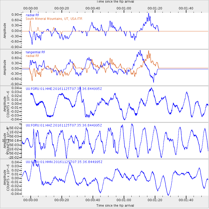
FORU South Mineral Mountains, UT, USA - Earthquake Result Viewer
*The percent match for this event was below the threshold and hence no stack was calculated.
| Earthquake location: |
Near East Coast Of Kamchatka |
| Earthquake latitude/longitude: |
54.4/160.6 |
| Earthquake time(UTC): |
2016/11/25 (330) 07:26:23 GMT |
| Earthquake Depth: |
84 km |
| Earthquake Magnitude: |
5.5 MB |
| Earthquake Catalog/Contributor: |
NEIC PDE/NEIC COMCAT |
|
| Network: |
UU University of Utah Regional Network |
| Station: |
FORU South Mineral Mountains, UT, USA |
| Lat/Lon: |
38.46 N/112.86 W |
| Elevation: |
1840 m |
|
| Distance: |
58.0 deg |
| Az: |
67.55 deg |
| Baz: |
316.547 deg |
| Ray Param: |
$rayparam |
*The percent match for this event was below the threshold and hence was not used in the summary stack. |
|
| Radial Match: |
54.84992 % |
| Radial Bump: |
400 |
| Transverse Match: |
54.46158 % |
| Transverse Bump: |
400 |
| SOD ConfigId: |
1858631 |
| Insert Time: |
2016-12-09 07:31:43.911 +0000 |
| GWidth: |
2.5 |
| Max Bumps: |
400 |
| Tol: |
0.001 |
|
Signal To Noise
| Channel | StoN | STA | LTA |
| UU:FORU:01:HHZ:20161125T07:35:36.844995Z | 2.080716 | 8.662213E-9 | 4.1630925E-9 |
| UU:FORU:01:HHN:20161125T07:35:36.844995Z | 1.8208277 | 3.975821E-8 | 2.183524E-8 |
| UU:FORU:01:HHE:20161125T07:35:36.844995Z | 1.114423 | 2.1292982E-8 | 1.910673E-8 |
| Arrivals |
| Ps | |
| PpPs | |
| PsPs/PpSs | |


