You are here: Home > Network List > TA - USArray Transportable Network (new EarthScope stations) Stations List
> Station C15A Salmond Ranch, Choteau, MT, USA > Earthquake Result Viewer
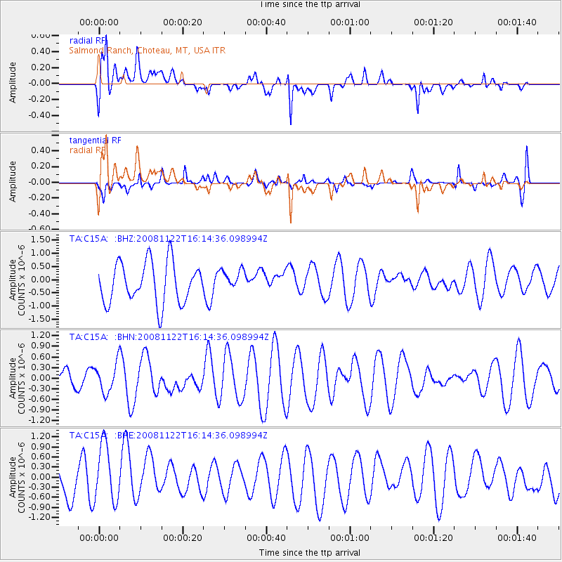
C15A Salmond Ranch, Choteau, MT, USA - Earthquake Result Viewer
*The percent match for this event was below the threshold and hence no stack was calculated.
| Earthquake location: |
Southeast Of Loyalty Islands |
| Earthquake latitude/longitude: |
-22.5/171.2 |
| Earthquake time(UTC): |
2008/11/22 (327) 16:01:39 GMT |
| Earthquake Depth: |
57 km |
| Earthquake Magnitude: |
5.7 MB, 6.4 MW, 6.4 MW |
| Earthquake Catalog/Contributor: |
WHDF/NEIC |
|
| Network: |
TA USArray Transportable Network (new EarthScope stations) |
| Station: |
C15A Salmond Ranch, Choteau, MT, USA |
| Lat/Lon: |
47.78 N/112.61 W |
| Elevation: |
1522 m |
|
| Distance: |
97.6 deg |
| Az: |
41.364 deg |
| Baz: |
244.943 deg |
| Ray Param: |
$rayparam |
*The percent match for this event was below the threshold and hence was not used in the summary stack. |
|
| Radial Match: |
70.18393 % |
| Radial Bump: |
400 |
| Transverse Match: |
34.547398 % |
| Transverse Bump: |
274 |
| SOD ConfigId: |
2658 |
| Insert Time: |
2010-03-07 00:32:45.866 +0000 |
| GWidth: |
2.5 |
| Max Bumps: |
400 |
| Tol: |
0.001 |
|
Signal To Noise
| Channel | StoN | STA | LTA |
| TA:C15A: :BHN:20081122T16:14:36.098994Z | 0.879851 | 4.1473442E-7 | 4.7136893E-7 |
| TA:C15A: :BHE:20081122T16:14:36.098994Z | 1.5482899 | 8.825221E-7 | 5.6999795E-7 |
| TA:C15A: :BHZ:20081122T16:14:36.098994Z | 0.5203842 | 4.0458514E-7 | 7.7747393E-7 |
| Arrivals |
| Ps | |
| PpPs | |
| PsPs/PpSs | |


