You are here: Home > Network List > TA - USArray Transportable Network (new EarthScope stations) Stations List
> Station C15A Salmond Ranch, Choteau, MT, USA > Earthquake Result Viewer
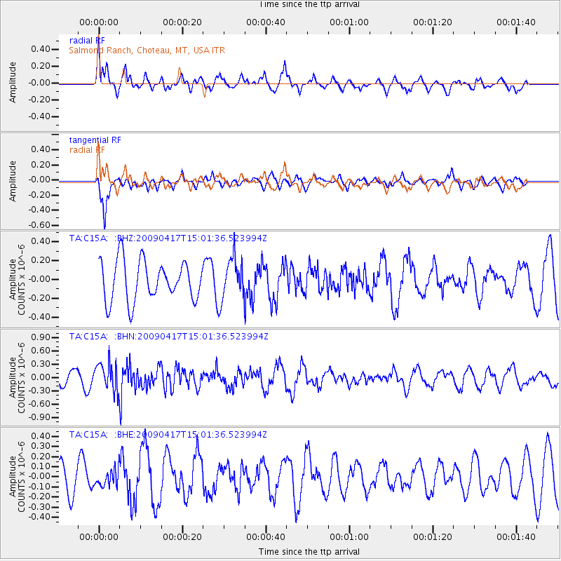
C15A Salmond Ranch, Choteau, MT, USA - Earthquake Result Viewer
*The percent match for this event was below the threshold and hence no stack was calculated.
| Earthquake location: |
Kuril Islands |
| Earthquake latitude/longitude: |
46.2/151.7 |
| Earthquake time(UTC): |
2009/04/17 (107) 14:51:58 GMT |
| Earthquake Depth: |
49 km |
| Earthquake Magnitude: |
5.5 MB, 5.0 MS, 5.7 MW, 5.6 MW |
| Earthquake Catalog/Contributor: |
WHDF/NEIC |
|
| Network: |
TA USArray Transportable Network (new EarthScope stations) |
| Station: |
C15A Salmond Ranch, Choteau, MT, USA |
| Lat/Lon: |
47.78 N/112.61 W |
| Elevation: |
1522 m |
|
| Distance: |
61.0 deg |
| Az: |
50.103 deg |
| Baz: |
307.772 deg |
| Ray Param: |
$rayparam |
*The percent match for this event was below the threshold and hence was not used in the summary stack. |
|
| Radial Match: |
59.12938 % |
| Radial Bump: |
352 |
| Transverse Match: |
61.86629 % |
| Transverse Bump: |
392 |
| SOD ConfigId: |
2658 |
| Insert Time: |
2010-03-07 00:32:52.058 +0000 |
| GWidth: |
2.5 |
| Max Bumps: |
400 |
| Tol: |
0.001 |
|
Signal To Noise
| Channel | StoN | STA | LTA |
| TA:C15A: :BHN:20090417T15:01:36.523994Z | 2.9386473 | 3.2070295E-7 | 1.0913285E-7 |
| TA:C15A: :BHE:20090417T15:01:36.523994Z | 0.8902416 | 8.1854616E-8 | 9.194651E-8 |
| TA:C15A: :BHZ:20090417T15:01:36.523994Z | 0.99932605 | 2.124082E-7 | 2.1255146E-7 |
| Arrivals |
| Ps | |
| PpPs | |
| PsPs/PpSs | |


