You are here: Home > Network List > TA - USArray Transportable Network (new EarthScope stations) Stations List
> Station B18A Beardsley Farm, Havre, MT, USA > Earthquake Result Viewer
B18A Beardsley Farm, Havre, MT, USA - Earthquake Result Viewer
| Earthquake location: |
Ryukyu Islands, Japan |
| Earthquake latitude/longitude: |
27.5/128.3 |
| Earthquake time(UTC): |
2008/07/08 (190) 07:42:10 GMT |
| Earthquake Depth: |
43 km |
| Earthquake Magnitude: |
6.0 MB, 5.5 MS, 6.0 MW, 6.0 MW |
| Earthquake Catalog/Contributor: |
WHDF/NEIC |
|
| Network: |
TA USArray Transportable Network (new EarthScope stations) |
| Station: |
B18A Beardsley Farm, Havre, MT, USA |
| Lat/Lon: |
48.39 N/109.78 W |
| Elevation: |
950 m |
|
| Distance: |
88.3 deg |
| Az: |
34.483 deg |
| Baz: |
311.032 deg |
| Ray Param: |
0.04264289 |
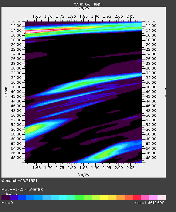
| Estimated Moho Depth: |
14.5 km |
| Estimated Crust Vp/Vs: |
1.60 |
| Assumed Crust Vp: |
6.438 km/s |
| Estimated Crust Vs: |
4.023 km/s |
| Estimated Crust Poisson's Ratio: |
0.18 |
|
| Radial Match: |
93.71551 % |
| Radial Bump: |
400 |
| Transverse Match: |
71.386505 % |
| Transverse Bump: |
400 |
| SOD ConfigId: |
2504 |
| Insert Time: |
2010-03-07 00:34:18.356 +0000 |
| GWidth: |
2.5 |
| Max Bumps: |
400 |
| Tol: |
0.001 |
|

Signal To Noise
| Channel | StoN | STA | LTA |
| TA:B18A: :BHN:20080708T07:54:26.37502Z | 24.152298 | 1.5496806E-6 | 6.416286E-8 |
| TA:B18A: :BHE:20080708T07:54:26.37502Z | 2.150113 | 3.8146064E-7 | 1.7741422E-7 |
| TA:B18A: :BHZ:20080708T07:54:26.37502Z | 4.212746 | 5.007111E-7 | 1.18856235E-7 |
| Arrivals |
| Ps | 1.4 SECOND |
| PpPs | 5.7 SECOND |
| PsPs/PpSs | 7.1 SECOND |


