You are here: Home > Network List > TA - USArray Transportable Network (new EarthScope stations) Stations List
> Station B18A Beardsley Farm, Havre, MT, USA > Earthquake Result Viewer
B18A Beardsley Farm, Havre, MT, USA - Earthquake Result Viewer
| Earthquake location: |
Bonin Islands, Japan Region |
| Earthquake latitude/longitude: |
26.8/142.4 |
| Earthquake time(UTC): |
2008/02/27 (058) 06:54:20 GMT |
| Earthquake Depth: |
15 km |
| Earthquake Magnitude: |
5.8 MB, 6.1 MS, 6.2 MW, 6.2 MW |
| Earthquake Catalog/Contributor: |
WHDF/NEIC |
|
| Network: |
TA USArray Transportable Network (new EarthScope stations) |
| Station: |
B18A Beardsley Farm, Havre, MT, USA |
| Lat/Lon: |
48.39 N/109.78 W |
| Elevation: |
950 m |
|
| Distance: |
81.2 deg |
| Az: |
39.953 deg |
| Baz: |
300.565 deg |
| Ray Param: |
0.0477289 |
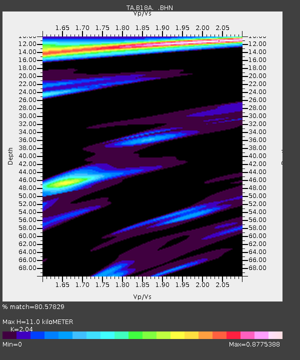
| Estimated Moho Depth: |
11.0 km |
| Estimated Crust Vp/Vs: |
2.04 |
| Assumed Crust Vp: |
6.438 km/s |
| Estimated Crust Vs: |
3.156 km/s |
| Estimated Crust Poisson's Ratio: |
0.34 |
|
| Radial Match: |
80.57829 % |
| Radial Bump: |
288 |
| Transverse Match: |
53.767536 % |
| Transverse Bump: |
394 |
| SOD ConfigId: |
2564 |
| Insert Time: |
2010-03-07 00:34:43.183 +0000 |
| GWidth: |
2.5 |
| Max Bumps: |
400 |
| Tol: |
0.001 |
|

Signal To Noise
| Channel | StoN | STA | LTA |
| TA:B18A: :BHN:20080227T07:06:04.325027Z | 0.7799362 | 1.9826268E-7 | 2.542037E-7 |
| TA:B18A: :BHE:20080227T07:06:04.325027Z | 1.5010778 | 3.6994592E-7 | 2.4645354E-7 |
| TA:B18A: :BHZ:20080227T07:06:04.325027Z | 2.9702802 | 6.7914357E-7 | 2.286463E-7 |
| Arrivals |
| Ps | 1.8 SECOND |
| PpPs | 5.1 SECOND |
| PsPs/PpSs | 6.9 SECOND |


