You are here: Home > Network List > TA - USArray Transportable Network (new EarthScope stations) Stations List
> Station B18A Beardsley Farm, Havre, MT, USA > Earthquake Result Viewer
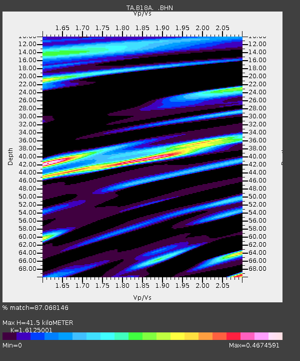
B18A Beardsley Farm, Havre, MT, USA - Earthquake Result Viewer
| Earthquake location: |
Santa Cruz Islands Region |
| Earthquake latitude/longitude: |
-11.0/164.5 |
| Earthquake time(UTC): |
2008/07/19 (201) 09:27:01 GMT |
| Earthquake Depth: |
11 km |
| Earthquake Magnitude: |
6.1 MB, 6.4 MS, 6.6 MW, 6.6 MW |
| Earthquake Catalog/Contributor: |
WHDF/NEIC |
|
| Network: |
TA USArray Transportable Network (new EarthScope stations) |
| Station: |
B18A Beardsley Farm, Havre, MT, USA |
| Lat/Lon: |
48.39 N/109.78 W |
| Elevation: |
950 m |
|
| Distance: |
95.3 deg |
| Az: |
41.878 deg |
| Baz: |
259.507 deg |
| Ray Param: |
0.040806808 |
| Estimated Moho Depth: |
41.5 km |
| Estimated Crust Vp/Vs: |
1.61 |
| Assumed Crust Vp: |
6.438 km/s |
| Estimated Crust Vs: |
3.992 km/s |
| Estimated Crust Poisson's Ratio: |
0.19 |
|
| Radial Match: |
87.068146 % |
| Radial Bump: |
377 |
| Transverse Match: |
82.46113 % |
| Transverse Bump: |
400 |
| SOD ConfigId: |
2658 |
| Insert Time: |
2010-03-07 00:34:44.076 +0000 |
| GWidth: |
2.5 |
| Max Bumps: |
400 |
| Tol: |
0.001 |
|

Signal To Noise
| Channel | StoN | STA | LTA |
| TA:B18A: :BHN:20080719T09:39:53.850015Z | 15.009253 | 1.1919326E-6 | 7.941319E-8 |
| TA:B18A: :BHE:20080719T09:39:53.850015Z | 0.9955113 | 1.06956556E-7 | 1.07438815E-7 |
| TA:B18A: :BHZ:20080719T09:39:53.850015Z | 4.3084946 | 4.592917E-7 | 1.0660143E-7 |
| Arrivals |
| Ps | 4.0 SECOND |
| PpPs | 16 SECOND |
| PsPs/PpSs | 21 SECOND |


