You are here: Home > Network List > TA - USArray Transportable Network (new EarthScope stations) Stations List
> Station O17K Koliganek, Bristol Bay, AK, USA > Earthquake Result Viewer
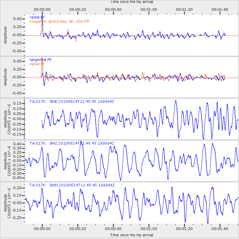
O17K Koliganek, Bristol Bay, AK, USA - Earthquake Result Viewer
| Earthquake location: |
Kermadec Islands, New Zealand |
| Earthquake latitude/longitude: |
-30.8/-177.4 |
| Earthquake time(UTC): |
2019/06/24 (175) 11:34:08 GMT |
| Earthquake Depth: |
10 km |
| Earthquake Magnitude: |
5.9 Mww |
| Earthquake Catalog/Contributor: |
NEIC PDE/us |
|
| Network: |
TA USArray Transportable Network (new EarthScope stations) |
| Station: |
O17K Koliganek, Bristol Bay, AK, USA |
| Lat/Lon: |
59.77 N/157.09 W |
| Elevation: |
156 m |
|
| Distance: |
91.8 deg |
| Az: |
10.107 deg |
| Baz: |
197.356 deg |
| Ray Param: |
0.041551054 |
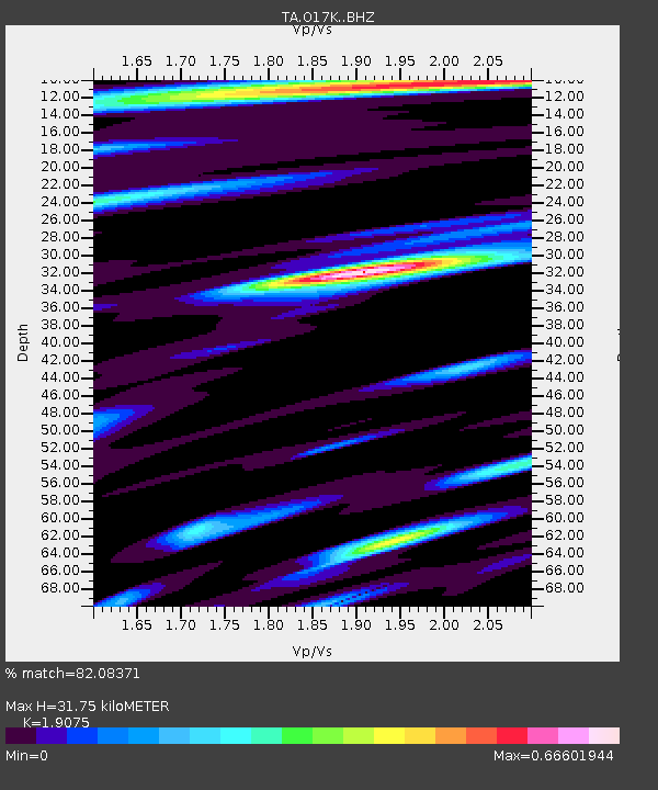
| Estimated Moho Depth: |
31.75 km |
| Estimated Crust Vp/Vs: |
1.91 |
| Assumed Crust Vp: |
6.276 km/s |
| Estimated Crust Vs: |
3.29 km/s |
| Estimated Crust Poisson's Ratio: |
0.31 |
|
| Radial Match: |
82.08371 % |
| Radial Bump: |
400 |
| Transverse Match: |
53.36562 % |
| Transverse Bump: |
400 |
| SOD ConfigId: |
18369291 |
| Insert Time: |
2019-07-08 11:40:21.231 +0000 |
| GWidth: |
2.5 |
| Max Bumps: |
400 |
| Tol: |
0.001 |
|
Signal To Noise
| Channel | StoN | STA | LTA |
| TA:O17K: :BHZ:20190624T11:46:45.199994Z | 3.2166252 | 2.2294844E-7 | 6.931129E-8 |
| TA:O17K: :BHN:20190624T11:46:45.199994Z | 1.9201895 | 9.22475E-8 | 4.8040828E-8 |
| TA:O17K: :BHE:20190624T11:46:45.199994Z | 1.7980459 | 8.161952E-8 | 4.539346E-8 |
| Arrivals |
| Ps | 4.7 SECOND |
| PpPs | 14 SECOND |
| PsPs/PpSs | 19 SECOND |


