You are here: Home > Network List > TA - USArray Transportable Network (new EarthScope stations) Stations List
> Station S12K Black Hills, AK, USA > Earthquake Result Viewer
S12K Black Hills, AK, USA - Earthquake Result Viewer
| Earthquake location: |
Kermadec Islands, New Zealand |
| Earthquake latitude/longitude: |
-30.8/-177.4 |
| Earthquake time(UTC): |
2019/06/24 (175) 11:34:08 GMT |
| Earthquake Depth: |
10 km |
| Earthquake Magnitude: |
5.9 Mww |
| Earthquake Catalog/Contributor: |
NEIC PDE/us |
|
| Network: |
TA USArray Transportable Network (new EarthScope stations) |
| Station: |
S12K Black Hills, AK, USA |
| Lat/Lon: |
55.70 N/162.06 W |
| Elevation: |
411 m |
|
| Distance: |
87.2 deg |
| Az: |
8.61 deg |
| Baz: |
193.148 deg |
| Ray Param: |
0.0435025 |
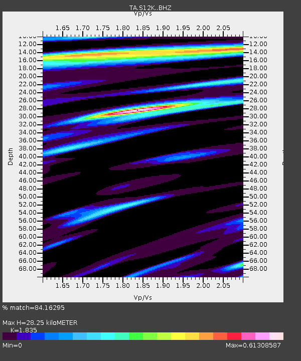
| Estimated Moho Depth: |
28.25 km |
| Estimated Crust Vp/Vs: |
1.84 |
| Assumed Crust Vp: |
5.989 km/s |
| Estimated Crust Vs: |
3.264 km/s |
| Estimated Crust Poisson's Ratio: |
0.29 |
|
| Radial Match: |
84.16295 % |
| Radial Bump: |
400 |
| Transverse Match: |
80.52546 % |
| Transverse Bump: |
400 |
| SOD ConfigId: |
18369291 |
| Insert Time: |
2019-07-08 11:40:33.690 +0000 |
| GWidth: |
2.5 |
| Max Bumps: |
400 |
| Tol: |
0.001 |
|

Signal To Noise
| Channel | StoN | STA | LTA |
| TA:S12K: :BHZ:20190624T11:46:23.499981Z | 9.999562 | 1.1484536E-6 | 1.1485039E-7 |
| TA:S12K: :BHN:20190624T11:46:23.499981Z | 2.5388508 | 2.2292737E-7 | 8.7806406E-8 |
| TA:S12K: :BHE:20190624T11:46:23.499981Z | 1.1786662 | 8.8387644E-8 | 7.4989536E-8 |
| Arrivals |
| Ps | 4.0 SECOND |
| PpPs | 13 SECOND |
| PsPs/PpSs | 17 SECOND |


