You are here: Home > Network List > IU - Global Seismograph Network (GSN - IRIS/USGS) Stations List
> Station PMG Port Moresby, New Guinea > Earthquake Result Viewer
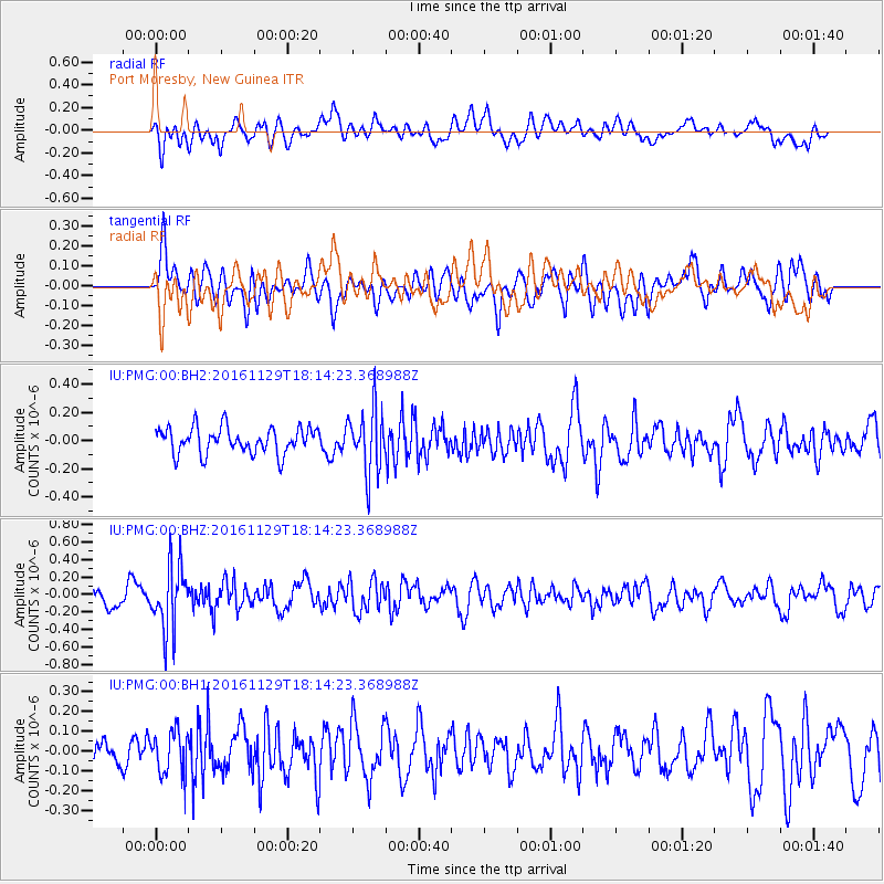
PMG Port Moresby, New Guinea - Earthquake Result Viewer
*The percent match for this event was below the threshold and hence no stack was calculated.
| Earthquake location: |
Tonga Islands |
| Earthquake latitude/longitude: |
-20.6/-175.2 |
| Earthquake time(UTC): |
2016/11/29 (334) 18:07:49 GMT |
| Earthquake Depth: |
133 km |
| Earthquake Magnitude: |
5.5 MB |
| Earthquake Catalog/Contributor: |
NEIC PDE/NEIC ALERT |
|
| Network: |
IU Global Seismograph Network (GSN - IRIS/USGS) |
| Station: |
PMG Port Moresby, New Guinea |
| Lat/Lon: |
9.40 S/147.16 E |
| Elevation: |
90 m |
|
| Distance: |
38.0 deg |
| Az: |
281.324 deg |
| Baz: |
111.396 deg |
| Ray Param: |
$rayparam |
*The percent match for this event was below the threshold and hence was not used in the summary stack. |
|
| Radial Match: |
57.193073 % |
| Radial Bump: |
400 |
| Transverse Match: |
58.80026 % |
| Transverse Bump: |
400 |
| SOD ConfigId: |
1858631 |
| Insert Time: |
2016-12-13 18:09:38.784 +0000 |
| GWidth: |
2.5 |
| Max Bumps: |
400 |
| Tol: |
0.001 |
|
Signal To Noise
| Channel | StoN | STA | LTA |
| IU:PMG:00:BHZ:20161129T18:14:23.368988Z | 3.190306 | 3.7102566E-7 | 1.16297834E-7 |
| IU:PMG:00:BH1:20161129T18:14:23.368988Z | 0.94211864 | 1.10062146E-7 | 1.16824076E-7 |
| IU:PMG:00:BH2:20161129T18:14:23.368988Z | 2.412937 | 2.2408317E-7 | 9.2867396E-8 |
| Arrivals |
| Ps | |
| PpPs | |
| PsPs/PpSs | |


