You are here: Home > Network List > UU - University of Utah Regional Network Stations List
> Station FORU South Mineral Mountains, UT, USA > Earthquake Result Viewer
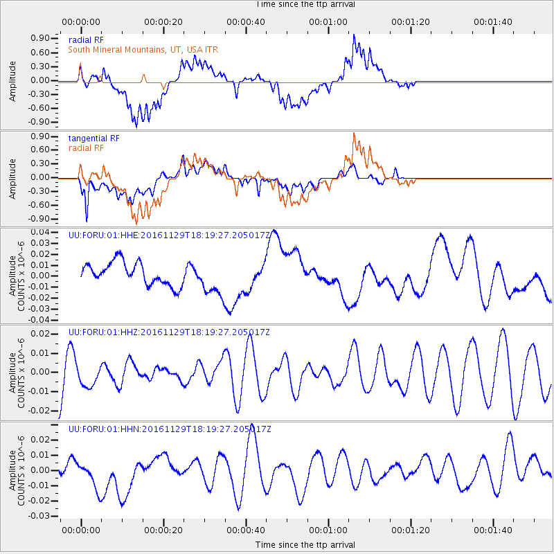
FORU South Mineral Mountains, UT, USA - Earthquake Result Viewer
*The percent match for this event was below the threshold and hence no stack was calculated.
| Earthquake location: |
Tonga Islands |
| Earthquake latitude/longitude: |
-20.6/-175.2 |
| Earthquake time(UTC): |
2016/11/29 (334) 18:07:49 GMT |
| Earthquake Depth: |
133 km |
| Earthquake Magnitude: |
5.5 MB |
| Earthquake Catalog/Contributor: |
NEIC PDE/NEIC ALERT |
|
| Network: |
UU University of Utah Regional Network |
| Station: |
FORU South Mineral Mountains, UT, USA |
| Lat/Lon: |
38.46 N/112.86 W |
| Elevation: |
1840 m |
|
| Distance: |
82.8 deg |
| Az: |
44.481 deg |
| Baz: |
236.743 deg |
| Ray Param: |
$rayparam |
*The percent match for this event was below the threshold and hence was not used in the summary stack. |
|
| Radial Match: |
63.88003 % |
| Radial Bump: |
400 |
| Transverse Match: |
76.320526 % |
| Transverse Bump: |
400 |
| SOD ConfigId: |
1858631 |
| Insert Time: |
2016-12-13 18:10:46.337 +0000 |
| GWidth: |
2.5 |
| Max Bumps: |
400 |
| Tol: |
0.001 |
|
Signal To Noise
| Channel | StoN | STA | LTA |
| UU:FORU:01:HHZ:20161129T18:19:27.205017Z | 0.5365749 | 5.4293445E-9 | 1.0118522E-8 |
| UU:FORU:01:HHN:20161129T18:19:27.205017Z | 1.660303 | 1.0335293E-8 | 6.224944E-9 |
| UU:FORU:01:HHE:20161129T18:19:27.205017Z | 1.6629888 | 1.6966776E-8 | 1.020258E-8 |
| Arrivals |
| Ps | |
| PpPs | |
| PsPs/PpSs | |


