You are here: Home > Network List > TA - USArray Transportable Network (new EarthScope stations) Stations List
> Station B18A Beardsley Farm, Havre, MT, USA > Earthquake Result Viewer
B18A Beardsley Farm, Havre, MT, USA - Earthquake Result Viewer
| Earthquake location: |
Honduras |
| Earthquake latitude/longitude: |
15.8/-86.9 |
| Earthquake time(UTC): |
2009/06/08 (159) 05:13:14 GMT |
| Earthquake Depth: |
10 km |
| Earthquake Magnitude: |
5.5 MB, 4.9 MS, 5.4 MW, 5.4 MW |
| Earthquake Catalog/Contributor: |
WHDF/NEIC |
|
| Network: |
TA USArray Transportable Network (new EarthScope stations) |
| Station: |
B18A Beardsley Farm, Havre, MT, USA |
| Lat/Lon: |
48.39 N/109.78 W |
| Elevation: |
950 m |
|
| Distance: |
37.6 deg |
| Az: |
334.811 deg |
| Baz: |
142.064 deg |
| Ray Param: |
0.07606639 |
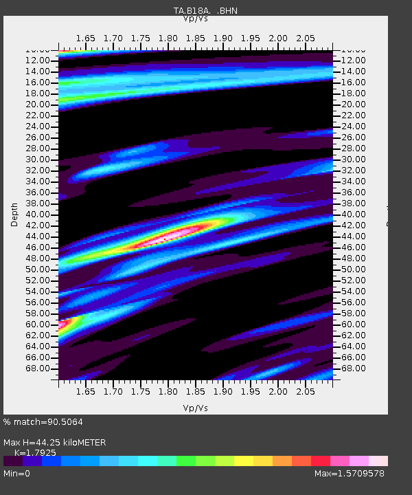
| Estimated Moho Depth: |
44.25 km |
| Estimated Crust Vp/Vs: |
1.79 |
| Assumed Crust Vp: |
6.438 km/s |
| Estimated Crust Vs: |
3.591 km/s |
| Estimated Crust Poisson's Ratio: |
0.27 |
|
| Radial Match: |
90.5064 % |
| Radial Bump: |
400 |
| Transverse Match: |
61.375916 % |
| Transverse Bump: |
400 |
| SOD ConfigId: |
2648 |
| Insert Time: |
2010-03-07 00:35:11.559 +0000 |
| GWidth: |
2.5 |
| Max Bumps: |
400 |
| Tol: |
0.001 |
|

Signal To Noise
| Channel | StoN | STA | LTA |
| TA:B18A: :BHN:20090608T05:19:58.250007Z | 10.915494 | 7.5835885E-7 | 6.947545E-8 |
| TA:B18A: :BHE:20090608T05:19:58.250007Z | 2.9558086 | 3.8707228E-7 | 1.309531E-7 |
| TA:B18A: :BHZ:20090608T05:19:58.250007Z | 1.4737613 | 1.9535815E-7 | 1.3255753E-7 |
| Arrivals |
| Ps | 5.9 SECOND |
| PpPs | 18 SECOND |
| PsPs/PpSs | 24 SECOND |


