You are here: Home > Network List > TA - USArray Transportable Network (new EarthScope stations) Stations List
> Station B18A Beardsley Farm, Havre, MT, USA > Earthquake Result Viewer
B18A Beardsley Farm, Havre, MT, USA - Earthquake Result Viewer
| Earthquake location: |
South Of Panama |
| Earthquake latitude/longitude: |
5.0/-82.7 |
| Earthquake time(UTC): |
2008/06/17 (169) 17:42:09 GMT |
| Earthquake Depth: |
10 km |
| Earthquake Magnitude: |
5.6 MB, 5.3 MS, 5.9 MW, 5.9 MW |
| Earthquake Catalog/Contributor: |
WHDF/NEIC |
|
| Network: |
TA USArray Transportable Network (new EarthScope stations) |
| Station: |
B18A Beardsley Farm, Havre, MT, USA |
| Lat/Lon: |
48.39 N/109.78 W |
| Elevation: |
950 m |
|
| Distance: |
49.0 deg |
| Az: |
336.27 deg |
| Baz: |
143.02 deg |
| Ray Param: |
0.06896289 |
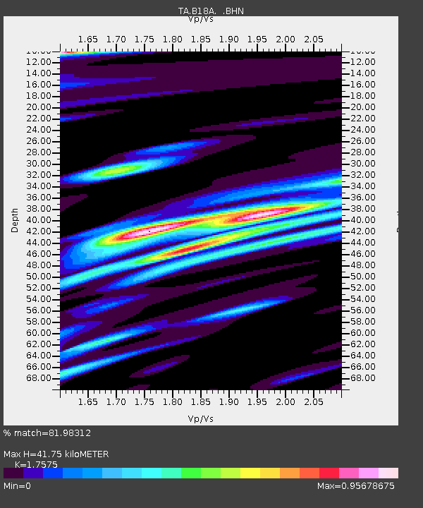
| Estimated Moho Depth: |
41.75 km |
| Estimated Crust Vp/Vs: |
1.76 |
| Assumed Crust Vp: |
6.438 km/s |
| Estimated Crust Vs: |
3.663 km/s |
| Estimated Crust Poisson's Ratio: |
0.26 |
|
| Radial Match: |
81.98312 % |
| Radial Bump: |
400 |
| Transverse Match: |
70.83047 % |
| Transverse Bump: |
400 |
| SOD ConfigId: |
2504 |
| Insert Time: |
2010-03-07 00:35:53.723 +0000 |
| GWidth: |
2.5 |
| Max Bumps: |
400 |
| Tol: |
0.001 |
|

Signal To Noise
| Channel | StoN | STA | LTA |
| TA:B18A: :BHN:20080617T17:50:25.698992Z | 13.974161 | 1.0392429E-6 | 7.43689E-8 |
| TA:B18A: :BHE:20080617T17:50:25.698992Z | 4.139964 | 3.5488927E-7 | 8.572279E-8 |
| TA:B18A: :BHZ:20080617T17:50:25.698992Z | 2.2925727 | 2.0777371E-7 | 9.062906E-8 |
| Arrivals |
| Ps | 5.2 SECOND |
| PpPs | 17 SECOND |
| PsPs/PpSs | 22 SECOND |


