You are here: Home > Network List > TA - USArray Transportable Network (new EarthScope stations) Stations List
> Station B18A Beardsley Farm, Havre, MT, USA > Earthquake Result Viewer
B18A Beardsley Farm, Havre, MT, USA - Earthquake Result Viewer
| Earthquake location: |
Tonga Islands |
| Earthquake latitude/longitude: |
-20.8/-173.3 |
| Earthquake time(UTC): |
2008/06/26 (178) 21:19:15 GMT |
| Earthquake Depth: |
38 km |
| Earthquake Magnitude: |
6.0 MB, 5.8 MS, 6.2 MW, 6.1 MW |
| Earthquake Catalog/Contributor: |
WHDF/NEIC |
|
| Network: |
TA USArray Transportable Network (new EarthScope stations) |
| Station: |
B18A Beardsley Farm, Havre, MT, USA |
| Lat/Lon: |
48.39 N/109.78 W |
| Elevation: |
950 m |
|
| Distance: |
89.1 deg |
| Az: |
36.646 deg |
| Baz: |
236.935 deg |
| Ray Param: |
0.04200968 |
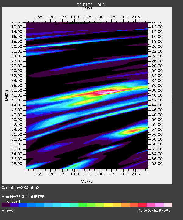
| Estimated Moho Depth: |
38.5 km |
| Estimated Crust Vp/Vs: |
1.94 |
| Assumed Crust Vp: |
6.438 km/s |
| Estimated Crust Vs: |
3.318 km/s |
| Estimated Crust Poisson's Ratio: |
0.32 |
|
| Radial Match: |
83.55953 % |
| Radial Bump: |
400 |
| Transverse Match: |
78.090775 % |
| Transverse Bump: |
353 |
| SOD ConfigId: |
2504 |
| Insert Time: |
2010-03-07 00:35:58.244 +0000 |
| GWidth: |
2.5 |
| Max Bumps: |
400 |
| Tol: |
0.001 |
|

Signal To Noise
| Channel | StoN | STA | LTA |
| TA:B18A: :BHN:20080626T21:31:35.900007Z | 17.142994 | 1.4216462E-6 | 8.29287E-8 |
| TA:B18A: :BHE:20080626T21:31:35.900007Z | 1.3526787 | 2.476429E-7 | 1.8307594E-7 |
| TA:B18A: :BHZ:20080626T21:31:35.900007Z | 4.0336537 | 5.615379E-7 | 1.3921321E-7 |
| Arrivals |
| Ps | 5.7 SECOND |
| PpPs | 17 SECOND |
| PsPs/PpSs | 23 SECOND |


