You are here: Home > Network List > TA - USArray Transportable Network (new EarthScope stations) Stations List
> Station D23K Nanushuk River, AK USA > Earthquake Result Viewer
D23K Nanushuk River, AK USA - Earthquake Result Viewer
| Earthquake location: |
Irian Jaya, Indonesia |
| Earthquake latitude/longitude: |
-2.7/138.4 |
| Earthquake time(UTC): |
2019/06/24 (175) 16:54:11 GMT |
| Earthquake Depth: |
19 km |
| Earthquake Magnitude: |
5.7 mb |
| Earthquake Catalog/Contributor: |
NEIC PDE/us |
|
| Network: |
TA USArray Transportable Network (new EarthScope stations) |
| Station: |
D23K Nanushuk River, AK USA |
| Lat/Lon: |
68.97 N/150.68 W |
| Elevation: |
406 m |
|
| Distance: |
85.7 deg |
| Az: |
20.008 deg |
| Baz: |
251.209 deg |
| Ray Param: |
0.044565305 |
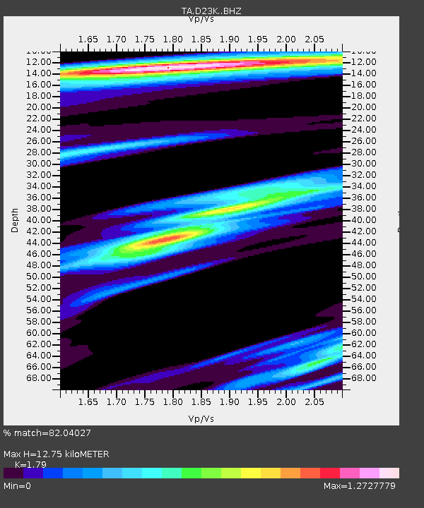
| Estimated Moho Depth: |
12.75 km |
| Estimated Crust Vp/Vs: |
1.79 |
| Assumed Crust Vp: |
6.221 km/s |
| Estimated Crust Vs: |
3.475 km/s |
| Estimated Crust Poisson's Ratio: |
0.27 |
|
| Radial Match: |
82.04027 % |
| Radial Bump: |
358 |
| Transverse Match: |
64.567444 % |
| Transverse Bump: |
400 |
| SOD ConfigId: |
18369291 |
| Insert Time: |
2019-07-08 16:59:49.169 +0000 |
| GWidth: |
2.5 |
| Max Bumps: |
400 |
| Tol: |
0.001 |
|
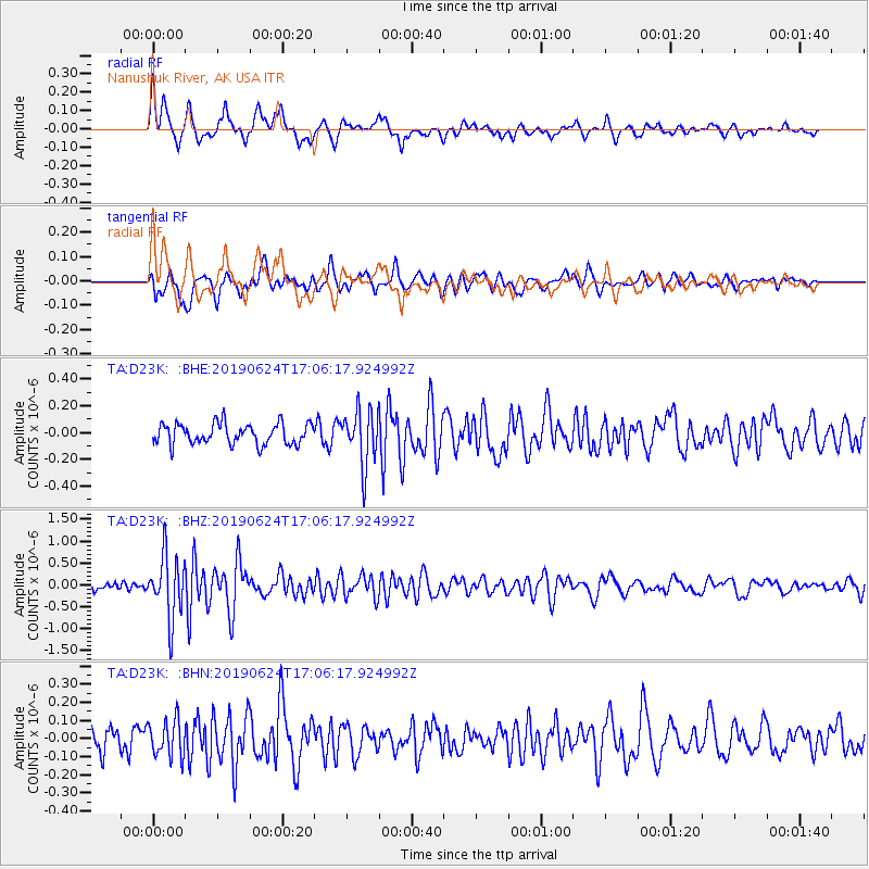
Signal To Noise
| Channel | StoN | STA | LTA |
| TA:D23K: :BHZ:20190624T17:06:17.924992Z | 4.7520375 | 7.0767504E-7 | 1.4892034E-7 |
| TA:D23K: :BHN:20190624T17:06:17.924992Z | 1.3554804 | 1.00563426E-7 | 7.419025E-8 |
| TA:D23K: :BHE:20190624T17:06:17.924992Z | 2.6770637 | 2.0658526E-7 | 7.716859E-8 |
| Arrivals |
| Ps | 1.7 SECOND |
| PpPs | 5.6 SECOND |
| PsPs/PpSs | 7.2 SECOND |


