You are here: Home > Network List > TA - USArray Transportable Network (new EarthScope stations) Stations List
> Station K13K Kusilvak Mountain, AK, USA > Earthquake Result Viewer
K13K Kusilvak Mountain, AK, USA - Earthquake Result Viewer
| Earthquake location: |
Irian Jaya, Indonesia |
| Earthquake latitude/longitude: |
-2.7/138.4 |
| Earthquake time(UTC): |
2019/06/24 (175) 16:54:11 GMT |
| Earthquake Depth: |
19 km |
| Earthquake Magnitude: |
5.7 mb |
| Earthquake Catalog/Contributor: |
NEIC PDE/us |
|
| Network: |
TA USArray Transportable Network (new EarthScope stations) |
| Station: |
K13K Kusilvak Mountain, AK, USA |
| Lat/Lon: |
61.93 N/164.66 W |
| Elevation: |
204 m |
|
| Distance: |
77.5 deg |
| Az: |
23.959 deg |
| Baz: |
239.059 deg |
| Ray Param: |
0.050296627 |
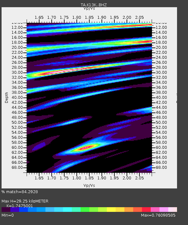
| Estimated Moho Depth: |
29.25 km |
| Estimated Crust Vp/Vs: |
1.75 |
| Assumed Crust Vp: |
6.1 km/s |
| Estimated Crust Vs: |
3.491 km/s |
| Estimated Crust Poisson's Ratio: |
0.26 |
|
| Radial Match: |
84.2928 % |
| Radial Bump: |
353 |
| Transverse Match: |
61.982212 % |
| Transverse Bump: |
400 |
| SOD ConfigId: |
18369291 |
| Insert Time: |
2019-07-08 17:00:25.865 +0000 |
| GWidth: |
2.5 |
| Max Bumps: |
400 |
| Tol: |
0.001 |
|

Signal To Noise
| Channel | StoN | STA | LTA |
| TA:K13K: :BHZ:20190624T17:05:34.549992Z | 6.2001567 | 4.0007907E-7 | 6.452725E-8 |
| TA:K13K: :BHN:20190624T17:05:34.549992Z | 1.4498026 | 8.6368E-8 | 5.9572244E-8 |
| TA:K13K: :BHE:20190624T17:05:34.549992Z | 2.2006648 | 1.6046096E-7 | 7.2914766E-8 |
| Arrivals |
| Ps | 3.7 SECOND |
| PpPs | 13 SECOND |
| PsPs/PpSs | 16 SECOND |


