You are here: Home > Network List > GS - US Geological Survey Networks Stations List
> Station OK030 Cody Creek RV Park, Cushing, OK, USA > Earthquake Result Viewer
OK030 Cody Creek RV Park, Cushing, OK, USA - Earthquake Result Viewer
| Earthquake location: |
Southern Peru |
| Earthquake latitude/longitude: |
-15.3/-70.8 |
| Earthquake time(UTC): |
2016/12/01 (336) 22:40:26 GMT |
| Earthquake Depth: |
10 km |
| Earthquake Magnitude: |
6.3 Mww |
| Earthquake Catalog/Contributor: |
NEIC PDE/us |
|
| Network: |
GS US Geological Survey Networks |
| Station: |
OK030 Cody Creek RV Park, Cushing, OK, USA |
| Lat/Lon: |
35.93 N/96.78 W |
| Elevation: |
289 m |
|
| Distance: |
56.6 deg |
| Az: |
334.807 deg |
| Baz: |
149.599 deg |
| Ray Param: |
0.06404751 |
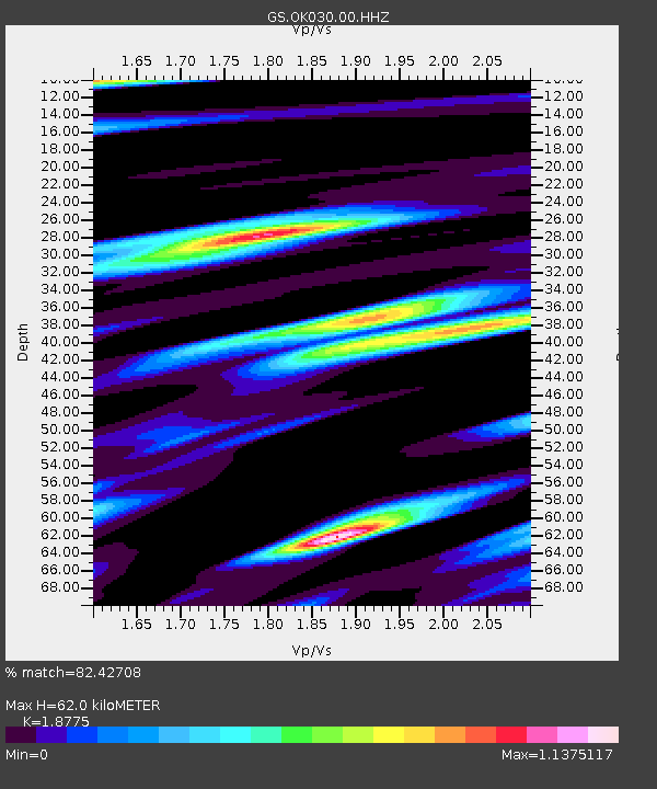
| Estimated Moho Depth: |
62.0 km |
| Estimated Crust Vp/Vs: |
1.88 |
| Assumed Crust Vp: |
6.426 km/s |
| Estimated Crust Vs: |
3.423 km/s |
| Estimated Crust Poisson's Ratio: |
0.30 |
|
| Radial Match: |
82.42708 % |
| Radial Bump: |
400 |
| Transverse Match: |
70.462585 % |
| Transverse Bump: |
400 |
| SOD ConfigId: |
1894071 |
| Insert Time: |
2016-12-15 22:44:11.852 +0000 |
| GWidth: |
2.5 |
| Max Bumps: |
400 |
| Tol: |
0.001 |
|

Signal To Noise
| Channel | StoN | STA | LTA |
| GS:OK030:00:HHZ:20161201T22:49:37.940022Z | 11.6533985 | 2.4858261E-6 | 2.1331341E-7 |
| GS:OK030:00:HH1:20161201T22:49:37.940022Z | 3.484165 | 1.0643977E-6 | 3.0549577E-7 |
| GS:OK030:00:HH2:20161201T22:49:37.940022Z | 2.7894044 | 8.051854E-7 | 2.8865853E-7 |
| Arrivals |
| Ps | 8.9 SECOND |
| PpPs | 26 SECOND |
| PsPs/PpSs | 35 SECOND |


