You are here: Home > Network List > TA - USArray Transportable Network (new EarthScope stations) Stations List
> Station M26K Nabesna, AK, USA > Earthquake Result Viewer
M26K Nabesna, AK, USA - Earthquake Result Viewer
| Earthquake location: |
Irian Jaya, Indonesia |
| Earthquake latitude/longitude: |
-2.7/138.4 |
| Earthquake time(UTC): |
2019/06/24 (175) 16:54:11 GMT |
| Earthquake Depth: |
19 km |
| Earthquake Magnitude: |
5.7 mb |
| Earthquake Catalog/Contributor: |
NEIC PDE/us |
|
| Network: |
TA USArray Transportable Network (new EarthScope stations) |
| Station: |
M26K Nabesna, AK, USA |
| Lat/Lon: |
62.40 N/143.00 W |
| Elevation: |
888 m |
|
| Distance: |
87.1 deg |
| Az: |
27.202 deg |
| Baz: |
258.673 deg |
| Ray Param: |
0.04358284 |
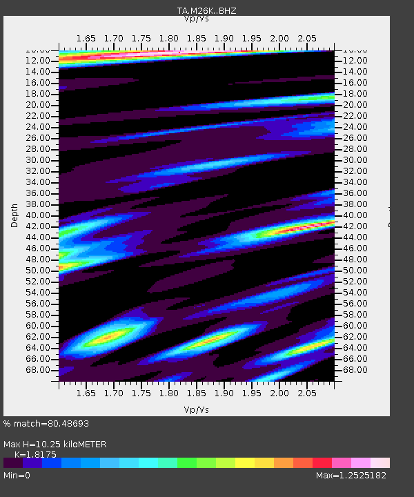
| Estimated Moho Depth: |
10.25 km |
| Estimated Crust Vp/Vs: |
1.82 |
| Assumed Crust Vp: |
6.566 km/s |
| Estimated Crust Vs: |
3.613 km/s |
| Estimated Crust Poisson's Ratio: |
0.28 |
|
| Radial Match: |
80.48693 % |
| Radial Bump: |
400 |
| Transverse Match: |
59.341076 % |
| Transverse Bump: |
400 |
| SOD ConfigId: |
18369291 |
| Insert Time: |
2019-07-08 17:00:41.949 +0000 |
| GWidth: |
2.5 |
| Max Bumps: |
400 |
| Tol: |
0.001 |
|

Signal To Noise
| Channel | StoN | STA | LTA |
| TA:M26K: :BHZ:20190624T17:06:24.59998Z | 3.570635 | 2.065135E-7 | 5.783663E-8 |
| TA:M26K: :BHN:20190624T17:06:24.59998Z | 0.5932428 | 3.9452654E-8 | 6.650338E-8 |
| TA:M26K: :BHE:20190624T17:06:24.59998Z | 0.64033216 | 4.4692918E-8 | 6.979646E-8 |
| Arrivals |
| Ps | 1.3 SECOND |
| PpPs | 4.3 SECOND |
| PsPs/PpSs | 5.6 SECOND |


