You are here: Home > Network List > TA - USArray Transportable Network (new EarthScope stations) Stations List
> Station B18K Kokolik River, AK, USA > Earthquake Result Viewer
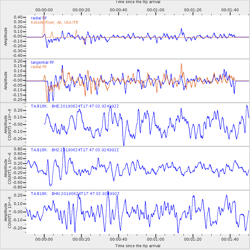
B18K Kokolik River, AK, USA - Earthquake Result Viewer
*The percent match for this event was below the threshold and hence no stack was calculated.
| Earthquake location: |
Irian Jaya, Indonesia |
| Earthquake latitude/longitude: |
-2.8/138.4 |
| Earthquake time(UTC): |
2019/06/24 (175) 17:35:13 GMT |
| Earthquake Depth: |
10 km |
| Earthquake Magnitude: |
5.3 Mww |
| Earthquake Catalog/Contributor: |
NEIC PDE/us |
|
| Network: |
TA USArray Transportable Network (new EarthScope stations) |
| Station: |
B18K Kokolik River, AK, USA |
| Lat/Lon: |
69.36 N/161.80 W |
| Elevation: |
222 m |
|
| Distance: |
82.3 deg |
| Az: |
18.014 deg |
| Baz: |
240.613 deg |
| Ray Param: |
$rayparam |
*The percent match for this event was below the threshold and hence was not used in the summary stack. |
|
| Radial Match: |
85.96273 % |
| Radial Bump: |
400 |
| Transverse Match: |
59.93856 % |
| Transverse Bump: |
400 |
| SOD ConfigId: |
18369291 |
| Insert Time: |
2019-07-08 17:37:49.996 +0000 |
| GWidth: |
2.5 |
| Max Bumps: |
400 |
| Tol: |
0.001 |
|
Signal To Noise
| Channel | StoN | STA | LTA |
| TA:B18K: :BHZ:20190624T17:47:03.924992Z | 2.4874322 | 4.035288E-7 | 1.6222705E-7 |
| TA:B18K: :BHN:20190624T17:47:03.924992Z | 0.9971587 | 6.373952E-8 | 6.3921135E-8 |
| TA:B18K: :BHE:20190624T17:47:03.924992Z | 1.1187692 | 1.04447146E-7 | 9.335898E-8 |
| Arrivals |
| Ps | |
| PpPs | |
| PsPs/PpSs | |


