You are here: Home > Network List > TA - USArray Transportable Network (new EarthScope stations) Stations List
> Station B17A L&G Farms, Chester, MT, USA > Earthquake Result Viewer
B17A L&G Farms, Chester, MT, USA - Earthquake Result Viewer

| Earthquake location: |
Sichuan, China |
| Earthquake latitude/longitude: |
32.8/105.5 |
| Earthquake time(UTC): |
2008/08/05 (218) 09:49:17 GMT |
| Earthquake Depth: |
6.0 km |
| Earthquake Magnitude: |
5.9 MB, 6.0 MS, 6.0 MW, 5.9 MW |
| Earthquake Catalog/Contributor: |
WHDF/NEIC |
|
| Network: |
TA USArray Transportable Network (new EarthScope stations) |
| Station: |
B17A L&G Farms, Chester, MT, USA |
| Lat/Lon: |
48.29 N/110.80 W |
| Elevation: |
894 m |
|
| Distance: |
93.0 deg |
| Az: |
23.319 deg |
| Baz: |
330.036 deg |
| Ray Param: |
0.041344445 |
| Estimated Moho Depth: |
40.0 km |
| Estimated Crust Vp/Vs: |
1.75 |
| Assumed Crust Vp: |
6.242 km/s |
| Estimated Crust Vs: |
3.567 km/s |
| Estimated Crust Poisson's Ratio: |
0.26 |
|
| Radial Match: |
91.682495 % |
| Radial Bump: |
394 |
| Transverse Match: |
78.99613 % |
| Transverse Bump: |
400 |
| SOD ConfigId: |
2504 |
| Insert Time: |
2010-03-07 00:38:26.665 +0000 |
| GWidth: |
2.5 |
| Max Bumps: |
400 |
| Tol: |
0.001 |
|
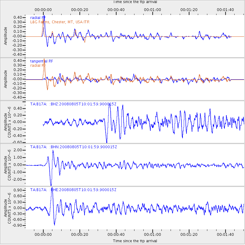
Signal To Noise
| Channel | StoN | STA | LTA |
| TA:B17A: :BHN:20080805T10:01:59.900015Z | 28.141401 | 1.1030899E-6 | 3.9198113E-8 |
| TA:B17A: :BHE:20080805T10:01:59.900015Z | 4.86005 | 3.3677512E-7 | 6.929457E-8 |
| TA:B17A: :BHZ:20080805T10:01:59.900015Z | 3.2470384 | 1.7123297E-7 | 5.2735125E-8 |
| Arrivals |
| Ps | 4.9 SECOND |
| PpPs | 17 SECOND |
| PsPs/PpSs | 22 SECOND |


