You are here: Home > Network List > TA - USArray Transportable Network (new EarthScope stations) Stations List
> Station O17K Koliganek, Bristol Bay, AK, USA > Earthquake Result Viewer
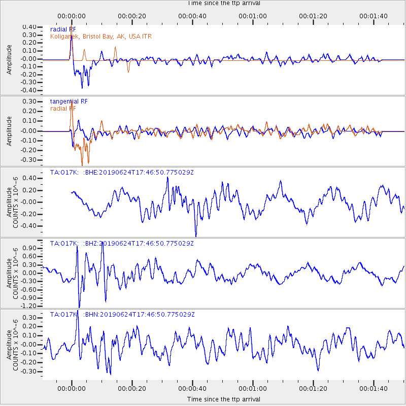
O17K Koliganek, Bristol Bay, AK, USA - Earthquake Result Viewer
| Earthquake location: |
Irian Jaya, Indonesia |
| Earthquake latitude/longitude: |
-2.8/138.4 |
| Earthquake time(UTC): |
2019/06/24 (175) 17:35:13 GMT |
| Earthquake Depth: |
10 km |
| Earthquake Magnitude: |
5.3 Mww |
| Earthquake Catalog/Contributor: |
NEIC PDE/us |
|
| Network: |
TA USArray Transportable Network (new EarthScope stations) |
| Station: |
O17K Koliganek, Bristol Bay, AK, USA |
| Lat/Lon: |
59.77 N/157.09 W |
| Elevation: |
156 m |
|
| Distance: |
79.9 deg |
| Az: |
27.649 deg |
| Baz: |
246.368 deg |
| Ray Param: |
0.048671156 |
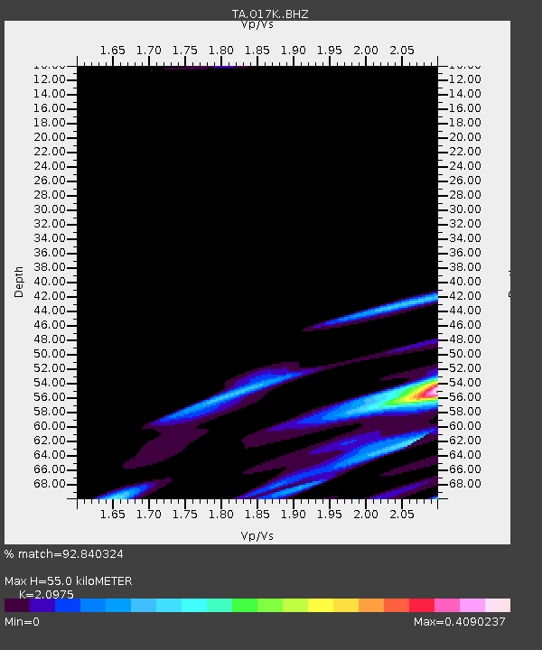
| Estimated Moho Depth: |
55.0 km |
| Estimated Crust Vp/Vs: |
2.10 |
| Assumed Crust Vp: |
6.276 km/s |
| Estimated Crust Vs: |
2.992 km/s |
| Estimated Crust Poisson's Ratio: |
0.35 |
|
| Radial Match: |
92.840324 % |
| Radial Bump: |
318 |
| Transverse Match: |
69.13999 % |
| Transverse Bump: |
400 |
| SOD ConfigId: |
18369291 |
| Insert Time: |
2019-07-08 17:38:46.746 +0000 |
| GWidth: |
2.5 |
| Max Bumps: |
400 |
| Tol: |
0.001 |
|
Signal To Noise
| Channel | StoN | STA | LTA |
| TA:O17K: :BHZ:20190624T17:46:50.775029Z | 3.1774123 | 5.4913556E-7 | 1.7282477E-7 |
| TA:O17K: :BHN:20190624T17:46:50.775029Z | 1.8973814 | 1.3617392E-7 | 7.17694E-8 |
| TA:O17K: :BHE:20190624T17:46:50.775029Z | 1.2604213 | 1.8406828E-7 | 1.4603712E-7 |
| Arrivals |
| Ps | 9.8 SECOND |
| PpPs | 27 SECOND |
| PsPs/PpSs | 36 SECOND |


