You are here: Home > Network List > TA - USArray Transportable Network (new EarthScope stations) Stations List
> Station B17A L&G Farms, Chester, MT, USA > Earthquake Result Viewer
B17A L&G Farms, Chester, MT, USA - Earthquake Result Viewer
| Earthquake location: |
Sea Of Okhotsk |
| Earthquake latitude/longitude: |
54.2/154.3 |
| Earthquake time(UTC): |
2008/11/24 (329) 09:02:58 GMT |
| Earthquake Depth: |
492 km |
| Earthquake Magnitude: |
6.5 MB, 7.3 MW, 7.3 MW |
| Earthquake Catalog/Contributor: |
WHDF/NEIC |
|
| Network: |
TA USArray Transportable Network (new EarthScope stations) |
| Station: |
B17A L&G Farms, Chester, MT, USA |
| Lat/Lon: |
48.29 N/110.80 W |
| Elevation: |
894 m |
|
| Distance: |
55.3 deg |
| Az: |
54.011 deg |
| Baz: |
314.618 deg |
| Ray Param: |
0.06287613 |
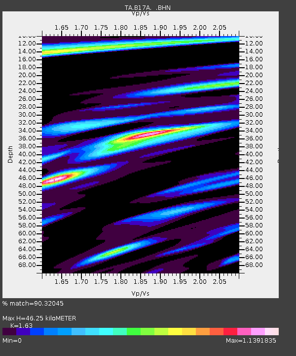
| Estimated Moho Depth: |
46.25 km |
| Estimated Crust Vp/Vs: |
1.63 |
| Assumed Crust Vp: |
6.242 km/s |
| Estimated Crust Vs: |
3.829 km/s |
| Estimated Crust Poisson's Ratio: |
0.20 |
|
| Radial Match: |
90.32045 % |
| Radial Bump: |
346 |
| Transverse Match: |
68.89049 % |
| Transverse Bump: |
400 |
| SOD ConfigId: |
2658 |
| Insert Time: |
2010-03-07 00:39:07.296 +0000 |
| GWidth: |
2.5 |
| Max Bumps: |
400 |
| Tol: |
0.001 |
|

Signal To Noise
| Channel | StoN | STA | LTA |
| TA:B17A: :BHN:20081124T09:11:14.425009Z | 5.6951647 | 2.353377E-6 | 4.1322372E-7 |
| TA:B17A: :BHE:20081124T09:11:14.425009Z | 2.8525326 | 1.1301221E-6 | 3.9618203E-7 |
| TA:B17A: :BHZ:20081124T09:11:14.425009Z | 1.6739972 | 7.7559463E-7 | 4.6331897E-7 |
| Arrivals |
| Ps | 4.9 SECOND |
| PpPs | 19 SECOND |
| PsPs/PpSs | 23 SECOND |


