You are here: Home > Network List > TA - USArray Transportable Network (new EarthScope stations) Stations List
> Station B17A L&G Farms, Chester, MT, USA > Earthquake Result Viewer
B17A L&G Farms, Chester, MT, USA - Earthquake Result Viewer
| Earthquake location: |
Iceland |
| Earthquake latitude/longitude: |
64.0/-21.0 |
| Earthquake time(UTC): |
2008/05/29 (150) 15:46:00 GMT |
| Earthquake Depth: |
10 km |
| Earthquake Magnitude: |
6.0 MB, 6.2 MS, 6.3 MW, 6.2 MW |
| Earthquake Catalog/Contributor: |
WHDF/NEIC |
|
| Network: |
TA USArray Transportable Network (new EarthScope stations) |
| Station: |
B17A L&G Farms, Chester, MT, USA |
| Lat/Lon: |
48.29 N/110.80 W |
| Elevation: |
894 m |
|
| Distance: |
48.0 deg |
| Az: |
296.005 deg |
| Baz: |
36.376 deg |
| Ray Param: |
0.069641486 |
| Estimated Moho Depth: |
10.0 km |
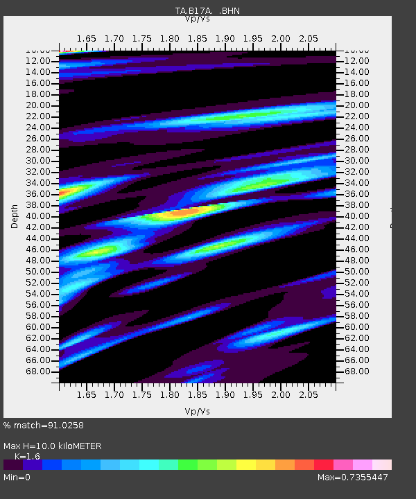
| Estimated Crust Vp/Vs: |
1.60 |
| Assumed Crust Vp: |
6.242 km/s |
| Estimated Crust Vs: |
3.901 km/s |
| Estimated Crust Poisson's Ratio: |
0.18 |
|
| Radial Match: |
91.0258 % |
| Radial Bump: |
385 |
| Transverse Match: |
73.94915 % |
| Transverse Bump: |
381 |
| SOD ConfigId: |
2504 |
| Insert Time: |
2010-03-07 00:39:45.293 +0000 |
| GWidth: |
2.5 |
| Max Bumps: |
400 |
| Tol: |
0.001 |
|
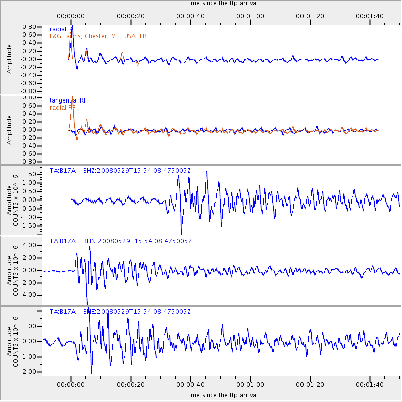
Signal To Noise
| Channel | StoN | STA | LTA |
| TA:B17A: :BHN:20080529T15:54:08.475005Z | 10.94138 | 1.206584E-6 | 1.10277135E-7 |
| TA:B17A: :BHE:20080529T15:54:08.475005Z | 3.2568672 | 4.6879256E-7 | 1.4393973E-7 |
| TA:B17A: :BHZ:20080529T15:54:08.475005Z | 3.1164396 | 3.0938486E-7 | 9.92751E-8 |
| Arrivals |
| Ps | 1.0 SECOND |
| PpPs | 3.9 SECOND |
| PsPs/PpSs | 4.9 SECOND |


