You are here: Home > Network List > CN - Canadian National Seismograph Network Stations List
> Station HG1B Mitchell Dam, BC, CA > Earthquake Result Viewer
HG1B Mitchell Dam, BC, CA - Earthquake Result Viewer
| Earthquake location: |
Komandorskiye Ostrova Region |
| Earthquake latitude/longitude: |
56.2/164.3 |
| Earthquake time(UTC): |
2019/06/25 (176) 09:05:44 GMT |
| Earthquake Depth: |
33 km |
| Earthquake Magnitude: |
6.6 Mi |
| Earthquake Catalog/Contributor: |
NEIC PDE/at |
|
| Network: |
CN Canadian National Seismograph Network |
| Station: |
HG1B Mitchell Dam, BC, CA |
| Lat/Lon: |
52.93 N/132.13 W |
| Elevation: |
5.0 m |
|
| Distance: |
35.8 deg |
| Az: |
67.779 deg |
| Baz: |
301.271 deg |
| Ray Param: |
0.07694478 |
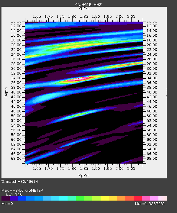
| Estimated Moho Depth: |
34.0 km |
| Estimated Crust Vp/Vs: |
1.83 |
| Assumed Crust Vp: |
6.183 km/s |
| Estimated Crust Vs: |
3.388 km/s |
| Estimated Crust Poisson's Ratio: |
0.29 |
|
| Radial Match: |
80.46614 % |
| Radial Bump: |
342 |
| Transverse Match: |
42.526627 % |
| Transverse Bump: |
370 |
| SOD ConfigId: |
18369291 |
| Insert Time: |
2019-07-09 09:08:18.365 +0000 |
| GWidth: |
2.5 |
| Max Bumps: |
400 |
| Tol: |
0.001 |
|

Signal To Noise
| Channel | StoN | STA | LTA |
| CN:HG1B: :HHZ:20190625T09:12:10.119995Z | 2.8688476 | 3.1800218E-7 | 1.1084666E-7 |
| CN:HG1B: :HHN:20190625T09:12:10.119995Z | 1.8640194 | 4.707561E-7 | 2.5254894E-7 |
| CN:HG1B: :HHE:20190625T09:12:10.119995Z | 1.9986577 | 2.957102E-7 | 1.4795441E-7 |
| Arrivals |
| Ps | 4.9 SECOND |
| PpPs | 15 SECOND |
| PsPs/PpSs | 19 SECOND |


