You are here: Home > Network List > TA - USArray Transportable Network (new EarthScope stations) Stations List
> Station B17A L&G Farms, Chester, MT, USA > Earthquake Result Viewer
B17A L&G Farms, Chester, MT, USA - Earthquake Result Viewer
*The percent match for this event was below the threshold and hence no stack was calculated.
| Earthquake location: |
Bonin Islands, Japan Region |
| Earthquake latitude/longitude: |
27.0/142.6 |
| Earthquake time(UTC): |
2008/03/14 (074) 22:32:09 GMT |
| Earthquake Depth: |
11 km |
| Earthquake Magnitude: |
5.7 MB, 5.9 MS, 6.0 MW, 6.0 MW |
| Earthquake Catalog/Contributor: |
WHDF/NEIC |
|
| Network: |
TA USArray Transportable Network (new EarthScope stations) |
| Station: |
B17A L&G Farms, Chester, MT, USA |
| Lat/Lon: |
48.29 N/110.80 W |
| Elevation: |
894 m |
|
| Distance: |
80.5 deg |
| Az: |
40.462 deg |
| Baz: |
299.875 deg |
| Ray Param: |
$rayparam |
*The percent match for this event was below the threshold and hence was not used in the summary stack. |
|
| Radial Match: |
73.65728 % |
| Radial Bump: |
400 |
| Transverse Match: |
50.3952 % |
| Transverse Bump: |
354 |
| SOD ConfigId: |
2504 |
| Insert Time: |
2010-03-07 00:40:01.574 +0000 |
| GWidth: |
2.5 |
| Max Bumps: |
400 |
| Tol: |
0.001 |
|
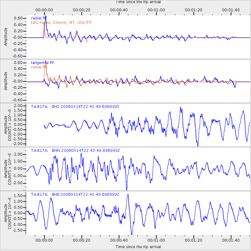
Signal To Noise
| Channel | StoN | STA | LTA |
| TA:B17A: :BHN:20080314T22:43:49.898999Z | 2.9443688 | 7.7449494E-7 | 2.6304278E-7 |
| TA:B17A: :BHE:20080314T22:43:49.898999Z | 4.1116242 | 9.093953E-7 | 2.2117665E-7 |
| TA:B17A: :BHZ:20080314T22:43:49.898999Z | 1.9623779 | 4.7756515E-7 | 2.4336043E-7 |
| Arrivals |
| Ps | |
| PpPs | |
| PsPs/PpSs | |


