You are here: Home > Network List > TA - USArray Transportable Network (new EarthScope stations) Stations List
> Station B17A L&G Farms, Chester, MT, USA > Earthquake Result Viewer
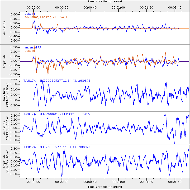
B17A L&G Farms, Chester, MT, USA - Earthquake Result Viewer
*The percent match for this event was below the threshold and hence no stack was calculated.
| Earthquake location: |
Near Coast Of Guatemala |
| Earthquake latitude/longitude: |
13.6/-91.0 |
| Earthquake time(UTC): |
2008/05/27 (148) 11:27:55 GMT |
| Earthquake Depth: |
26 km |
| Earthquake Magnitude: |
5.7 MW, 5.1 MS, 5.3 MB, 5.6 MW |
| Earthquake Catalog/Contributor: |
WHDF/NEIC |
|
| Network: |
TA USArray Transportable Network (new EarthScope stations) |
| Station: |
B17A L&G Farms, Chester, MT, USA |
| Lat/Lon: |
48.29 N/110.80 W |
| Elevation: |
894 m |
|
| Distance: |
38.3 deg |
| Az: |
338.601 deg |
| Baz: |
147.914 deg |
| Ray Param: |
$rayparam |
*The percent match for this event was below the threshold and hence was not used in the summary stack. |
|
| Radial Match: |
54.965088 % |
| Radial Bump: |
400 |
| Transverse Match: |
32.538853 % |
| Transverse Bump: |
322 |
| SOD ConfigId: |
2504 |
| Insert Time: |
2010-03-07 00:40:09.961 +0000 |
| GWidth: |
2.5 |
| Max Bumps: |
400 |
| Tol: |
0.001 |
|
Signal To Noise
| Channel | StoN | STA | LTA |
| TA:B17A: :BHN:20080527T11:34:43.198987Z | 2.9982178 | 1.7588755E-7 | 5.8664035E-8 |
| TA:B17A: :BHE:20080527T11:34:43.198987Z | 1.7178389 | 1.6378637E-7 | 9.5344426E-8 |
| TA:B17A: :BHZ:20080527T11:34:43.198987Z | 0.5682854 | 6.268265E-8 | 1.1030136E-7 |
| Arrivals |
| Ps | |
| PpPs | |
| PsPs/PpSs | |


