You are here: Home > Network List > JP - Japan Meteorological Agency Seismic Network Stations List
> Station JTU Tsushima Kamiagata > Earthquake Result Viewer
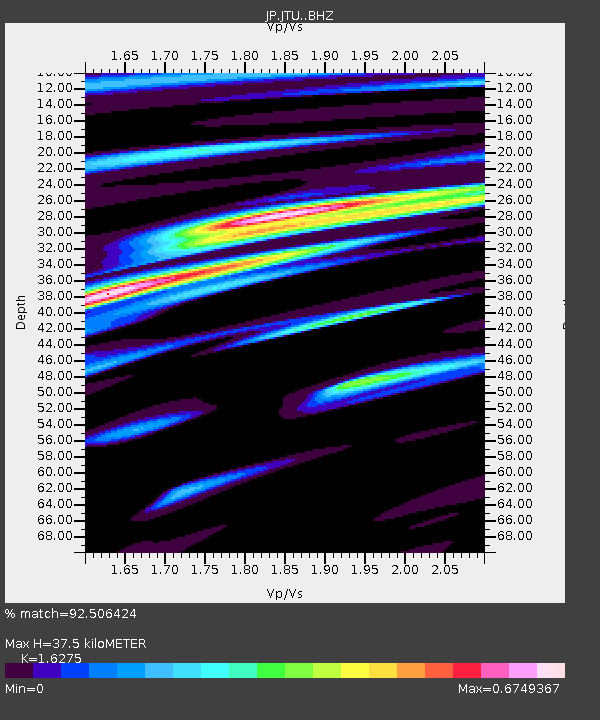
JTU Tsushima Kamiagata - Earthquake Result Viewer
| Earthquake location: |
Komandorskiye Ostrova Region |
| Earthquake latitude/longitude: |
56.2/164.3 |
| Earthquake time(UTC): |
2019/06/25 (176) 09:05:44 GMT |
| Earthquake Depth: |
33 km |
| Earthquake Magnitude: |
6.6 Mi |
| Earthquake Catalog/Contributor: |
NEIC PDE/at |
|
| Network: |
JP Japan Meteorological Agency Seismic Network |
| Station: |
JTU Tsushima Kamiagata |
| Lat/Lon: |
34.53 N/129.40 E |
| Elevation: |
70 m |
|
| Distance: |
32.2 deg |
| Az: |
242.477 deg |
| Baz: |
36.892 deg |
| Ray Param: |
0.07870813 |
| Estimated Moho Depth: |
37.5 km |
| Estimated Crust Vp/Vs: |
1.63 |
| Assumed Crust Vp: |
6.472 km/s |
| Estimated Crust Vs: |
3.977 km/s |
| Estimated Crust Poisson's Ratio: |
0.20 |
|
| Radial Match: |
92.506424 % |
| Radial Bump: |
332 |
| Transverse Match: |
77.53519 % |
| Transverse Bump: |
400 |
| SOD ConfigId: |
18369291 |
| Insert Time: |
2019-07-09 09:10:16.714 +0000 |
| GWidth: |
2.5 |
| Max Bumps: |
400 |
| Tol: |
0.001 |
|

Signal To Noise
| Channel | StoN | STA | LTA |
| JP:JTU: :BHZ:20190625T09:11:38.549988Z | 6.582727 | 1.0085834E-6 | 1.5321665E-7 |
| JP:JTU: :BHN:20190625T09:11:38.549988Z | 3.717464 | 4.814716E-7 | 1.2951615E-7 |
| JP:JTU: :BHE:20190625T09:11:38.549988Z | 2.6150172 | 4.000535E-7 | 1.5298312E-7 |
| Arrivals |
| Ps | 4.0 SECOND |
| PpPs | 14 SECOND |
| PsPs/PpSs | 18 SECOND |


